

holy mountain iii is a trail meditation through wy’east’s lesser traveled southside byways. picking up where the previous iterations left off, v3 expands to encompass the historic barlow road, skirting the wild bushlands of clear lake and the remote jackpot meadows trail.

The 2019 edition of the Holy Mountain is broken into three primary route variations, a 35 mile upper loop, the 50 mile ‘lower lolly’ and the 83 mile epic. One might ask ‘what’s with the 50 and 83 mile versions starting at Sandy Ridge and the 35 miler starting at Trillium?’ The answer is that it made the most sense in the context of a single-day event. We like to think of the 50 mile lower lolly as the ‘tortilla’ and the 35 mile upper loop as the ‘cheesy filling’. Taken together, of course the epic loop becomes the ‘whole enchilada’.
Now we’re hungry.
So why Sandy Ridge? Short answer is we thought it’d be funny in context. Bigger picture is we like the idea of blurring the lines between dropbar, adventure, gravel and mountain riding. Post-gravel? Jazzbikes? Whatever you want to call it, the only rule is…like, there are no rules, you dig? In reality these routes can be started at Sandy Ridge, Zig Zag Ranger Station, Road 19 Trailhead, Tollgate Campground or wherever you want really. When in doubt, see above.


Epic Route
The ‘Whole Enchilada’ features a gentle six-mile paved lead-out along Barlow Trail Road to the Road 19 trailhead, a wonderful culverted car-free forest connector to Henry Creek Road and the Tollgate entry to lower Pioneer Bridle. Our course climbs eastward along Pioneer Bridle as far as Road 32 at which point we pick up the south end of Still Creek Trail #780. Resist the temptation to cut across and jump onto Still Creek Trail early as the section between Pioneer Bridle and Road 32 is steep, rocky and…well, just trust us. It’s better this way. The classic Still Creek Road climb never disappoints en route to the periphery of Trillium Lake ultimately merging from 26 into 35 as a necessary means of accessing 3531/Buzzard Point/Pioneer Woman’s Grave/Barlow Pass. A tiny road with many names, a stellar natural water fountain of unverified potability and one grandiose panoramic blast of Wy’east. Bask in the grandeur.

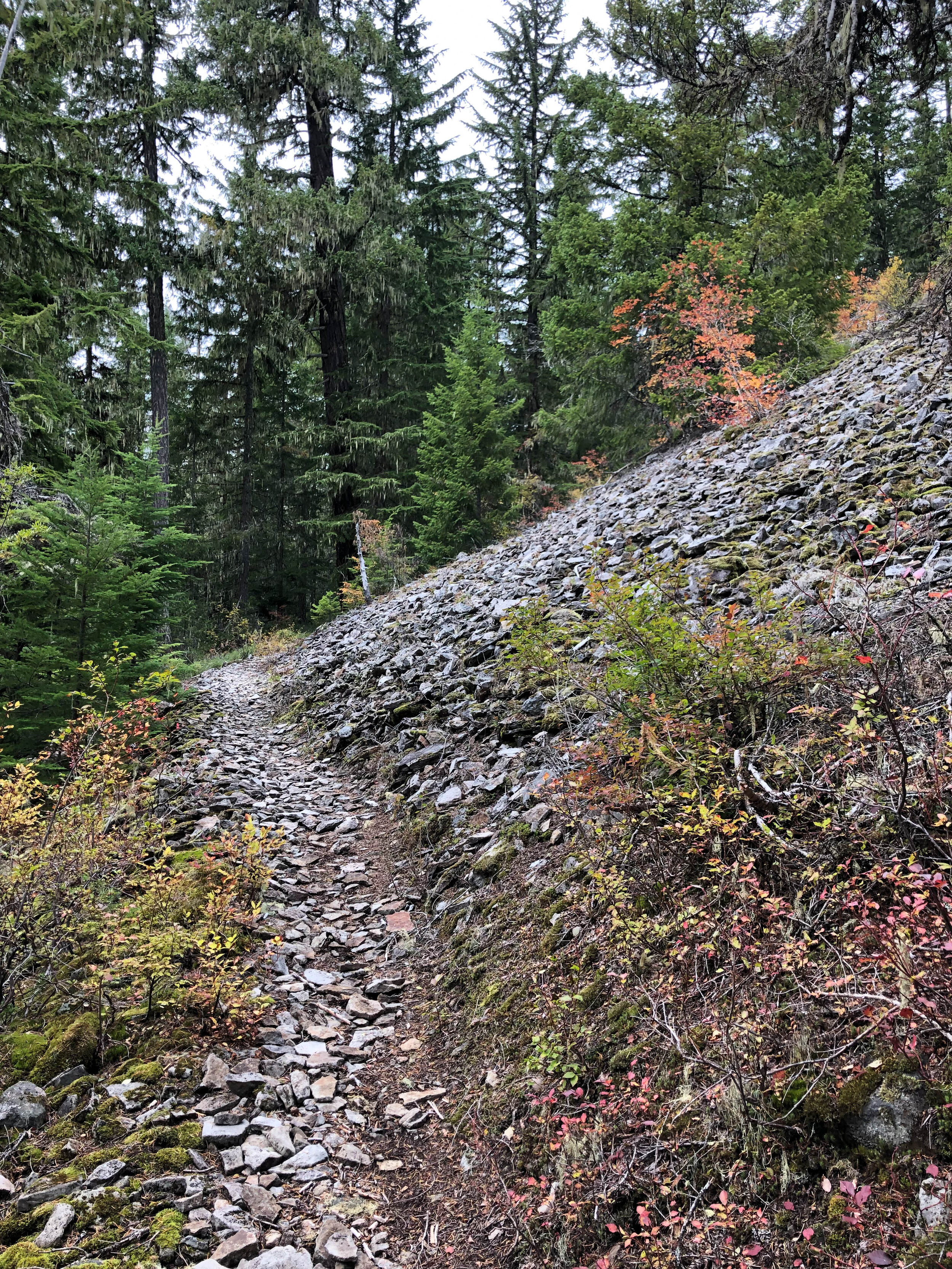
This will be our drop-in point to the Barlow Road. The original Oregon Trail and first ‘road’ built over the Cascade Range by Samuel Barlow between 1845-1846. Barlow is good. Very good. And by good I mean rocky, rutted, dark, piney, tortuous and tangly up top, smooth, flowing, sandy and dry down below. Some folks call it a ‘Jeep trail’, others a ‘primitive road’. We call it one of our favorite stretches in the Mt Hood National Forest.


Miles 34-41 are somewhat of a transport stage to Clear Lake via 43>2640. Kinda nondescript pavement-turned-gravel-chug. No big whoop. The line around Clear Lake utilizes a sandy shore loop temporarily accessible due to low water levels, connecting with the seldom-seen dark side of 2660 which traces the south rim of the lake. Be aware this stretch has been loosely decommissioned but is still 95% rideable if you know how to read the terrain. Visualize. Actualize. Facilitate and the line will reveal itself. A wily unnamed forest connector provides access to the more robust version of 2660, 58 and ultimately 240 to the south end of the Jackpot Meadows Trail.


Jackpot Meadows drops steeply down into the Salmon River drainage via tight rocky, mossy singletrack. This descent can be a bit spicy, so keep on your toes. Expect minor rock gardens, hidden roots, narrow off-camber trails and tight hairpin switchbacks through lush mossy evergreen forest intercut with slopes of exposed scree and waxy groves of rhododendron. After crossing the Salmon River on a narrow pedestrian bridge, the trail climbs gently northward to connect with 309>2656 en route to Trillium Lake once again.


This time around the course takes the Trillium Loop to Trillium Bike Trails en route to Perry Vickers and the west side of Barlow, crossing 26 into Government Camp. This will be the one and only opportunity for services along the route. Snacks. Coffee. Hoagies. Pancakes. Kombucha. Bulleit Rye. Hazy IPA. It’s all there in Government Camp. Our route picks up the Crosstown Trail at the north end of East Mucoy Street. Crosstown winds above Govy to pick up Pioneer Bridle at mile 62.8. Also note there is a fun diversion along Glacier View Road accessing a secret skatepark and some wonderfully decommissioned-yet-recommissioned tarmac-chunk-as-singletrack. It’s noncommittal and certainly worth a look, reconnecting to Pioneer Bridle at mile 63.5.


As a descent, upper Pioneer Bridle can be a bit harrowing on drop bars. Choose your lines carefully. There are steep chunky rock chutes, gnarly roots and technical woodland features. Imagine yourself hurtling down a dry rocklined creekbed. Stay loose. This one jostles a bit. Don’t miss the hard left drop through the haunted witch’s tunnel. They say if you pass through the tunnel three times under a full moon you are treated to a free 8oz drip at the Starbucks in Sandy, but is likely just the stuff of legend. Pioneer Bridle crosses to the south side of 26 and smoothes out considerably into a fast, furious beeline back to the Tollgate Campground and the western terminus of the trail. Watch those waterbars on the way down. The remainder of the route retraces Henry Creek>Road 19 and finishes well…wherever you started.

83.5 miles
8095 FEET
ROUTE FORMAT: convoluted figure-8 loop
SURFACE: 65% UNPAVED, 10% PAVED, 25% SINGLETRACK
TIRES: MINIMUM OF 45C. 2” recommended. TUBELESS HIGHLY RECOMMENDED
BIKE: GRAVEL/adventure/hardtail
services: government camp (water filter recommended)
FULL RIDE WITH GPS ROUTE + GPX FILE
50 mile lower lolly
The Lower Lolly will be a streamlined version featuring the climb to and descent from Government Camp. This version will still include Trillium Lake before climbing north along the Barlow Road to the Crosstown Trail. As with the epic, start/finish points may vary depending on personal preference. The extra-credit loop at Sandy Ridge is of course mandatory for successful completion of the Lower Lolly. Nothing less will do.
50 miles
4882 feet
ROUTE FORMAT: lollypop on a stick
SURFACE: 65% UNPAVED, 10% PAVED, 25% SINGLETRACK
TIRES: MINIMUM OF 45C. 2” recommended. TUBELESS HIGHLY RECOMMENDED
BIKE: GRAVEL/adventure/hardtail
services: midway point in government camp (seasonal water spigots at still creek campground)
FULL RIDE WITH GPS ROUTE + GPX FILE
36 mile upper loop
This version will only be the upper, high-country loop. If you’re looking to get the most bang for your buck and it’s not snowcovered, this loop will feature the most remote and pristine backcountry areas of the two shorter options. There are no services along this version of the loop, however Government Camp is quite close to the start/finish.
36 miles
3303 feet
ROUTE FORMAT: loop
SURFACE: 65% UNPAVED, 10% PAVED, 25% SINGLETRACK
TIRES: MINIMUM OF 45C. 2” recommended. TUBELESS HIGHLY RECOMMENDED
BIKE: GRAVEL/adventure/hardtail
services: no services (seasonal water spigots at trillium lake and still creek campgrounds)
FULL RIDE WITH GPS ROUTE + GPX FILE

Terms of Use: As with each adventure route guide published on OMTM.CC, should you choose to cycle this route, do so at your own risk. Prior to setting out check current local weather, conditions, and land/road closures. While riding, obey all public and private land use restrictions and rules, carry proper safety and navigational equipment, and of course, follow the #leavenotrace guidelines. The information found herein is simply a planning resource to be used as a point of inspiration in conjunction with your own due-diligence. In spite of the fact that this route, associated GPS track (GPX and maps), and all route guidelines were prepared under diligent research by the specified contributor and/or contributors, the accuracy of such and judgement of the author is not guaranteed. OMTM.CC, its partners, associates, and contributors are in no way liable for personal injury, damage to personal property, or any other such situation that might happen to individual riders cycling or following this route.