

WHICH OF THE FOLLOWING STATEMENTS ARE FALSE:
A. apple pie is best served mid-ride
B. post canyon is only for mountain bikes
C. punchbowl falls is that place up in the gorge
D. oak ridge trail is a joy to climb

A is obviously demonstrably true. I would challenge you to find a more piquant seasoning than 40 miles and a few thousand feet.
C is of course, a trick question; there are several Punchbowl Falls, this deep-cut beauty, the famous one in the Gorge and others.
D will require expanding one’s definition of ‘joy’ to include ‘agony’ but what is one without the other?
Which leaves us with our answer: B is clearly false.
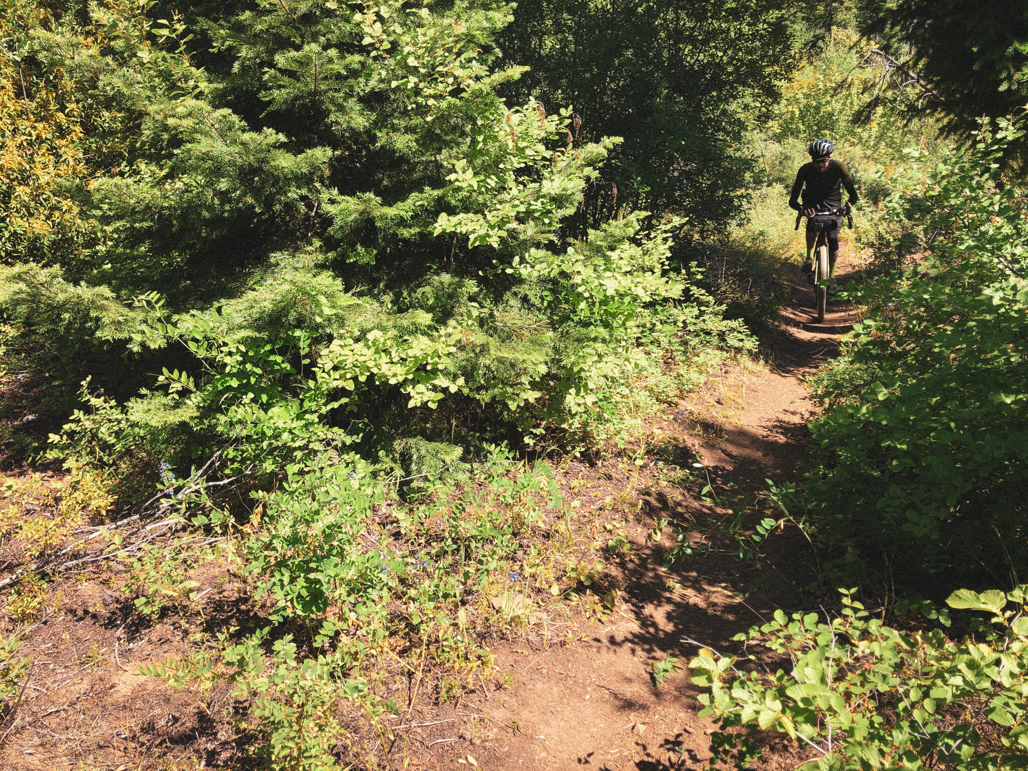
Don’t let Post Canyon’s bustle of tricked-out Sprinter vans and enduro rigs fool you, the system is ripe with fantastic drop-bar terrain if you know where to look. Not that you won’t get a snarky comment or a few side-eyes now and again, but if 2148 feet of ultra-premium drop-bar-friendly trail climbing is so wrong, I don’t want to be right. I like to think of drop-bars in MTB terrain as the telemark of cycling. Sure, cushier technology exists, but this method requires an elevated commitment to skill, finesse and handling.


We chose downtown Hood River as a central start and finish because, well, ample food options and good beer in abundant supply. But it is also worth pointing out that anyone can ride to these trails from the center of town, so we wanted to highlight the fact that outside of Portland these systems actually DO EXIST! The easy 6.5-mile roll over to Post Canyon serves as a gentle warm-up before jumping into singletrack at the Seven Streams staging area, one of several busy points of entry. Make no mistake, pristine wilderness this is not. Post Canyon is busy, dusty and rowdy but in this case serves as a fantastically dense trail leadout to a larger, multi-modal adventure day.
The initial trail sequence (Seven Streams Trail #100 > Toilet Bowl #100L) en route to the bustling Family Man staging area is climb enough to get things moving but isn’t going to blow out anyone’s legs early on. Traffic thankfully begins to thin on the climb away from Family Man. The #106, Eight Track (#150) and Upper El Dorodo trail progression has an appealing flow, quietly winding through Post’s iconic red clay up into an extended complex of switchbacks, steadily gaining elevation southwest along the ridge toward Riordon Hill and the terminus of the Upper El Dorado trail. Just around the bend is Binns Hill staging area and a return to pavement, thus concluding our whirlwind traversal of Post Canyon. Onward to phase 2 of our journey.


Cue scenery change.
Immediately past the staging area we are back on tarmac. Binns Hill dives steeply into a blistering series of tight curves, hurtling down through the creamy paved foothills and orchards above the Hood River Valley. Watch the hard right on Kingsley, it is easy to miss at speed. 3 miles south on Kingsley, one might see a curious unmarked gate on the left. What could be back there? It’s certainly not on the map. Beyond is a wonderfully wild but also oddly manicured former irrigation pipeline easement known to locals as the ‘Kingsley Ditch’. At mile 19.7, the track splits, one fork bearing left, the other, less-obvious path forward will be the one. This cutoff runs in and out of shady forest cover along the Pine Creek drainage, eventually emerging to a full-frontal blast of Mt. Hood in all its radiant glory.
Hark! It be a very large mountain!

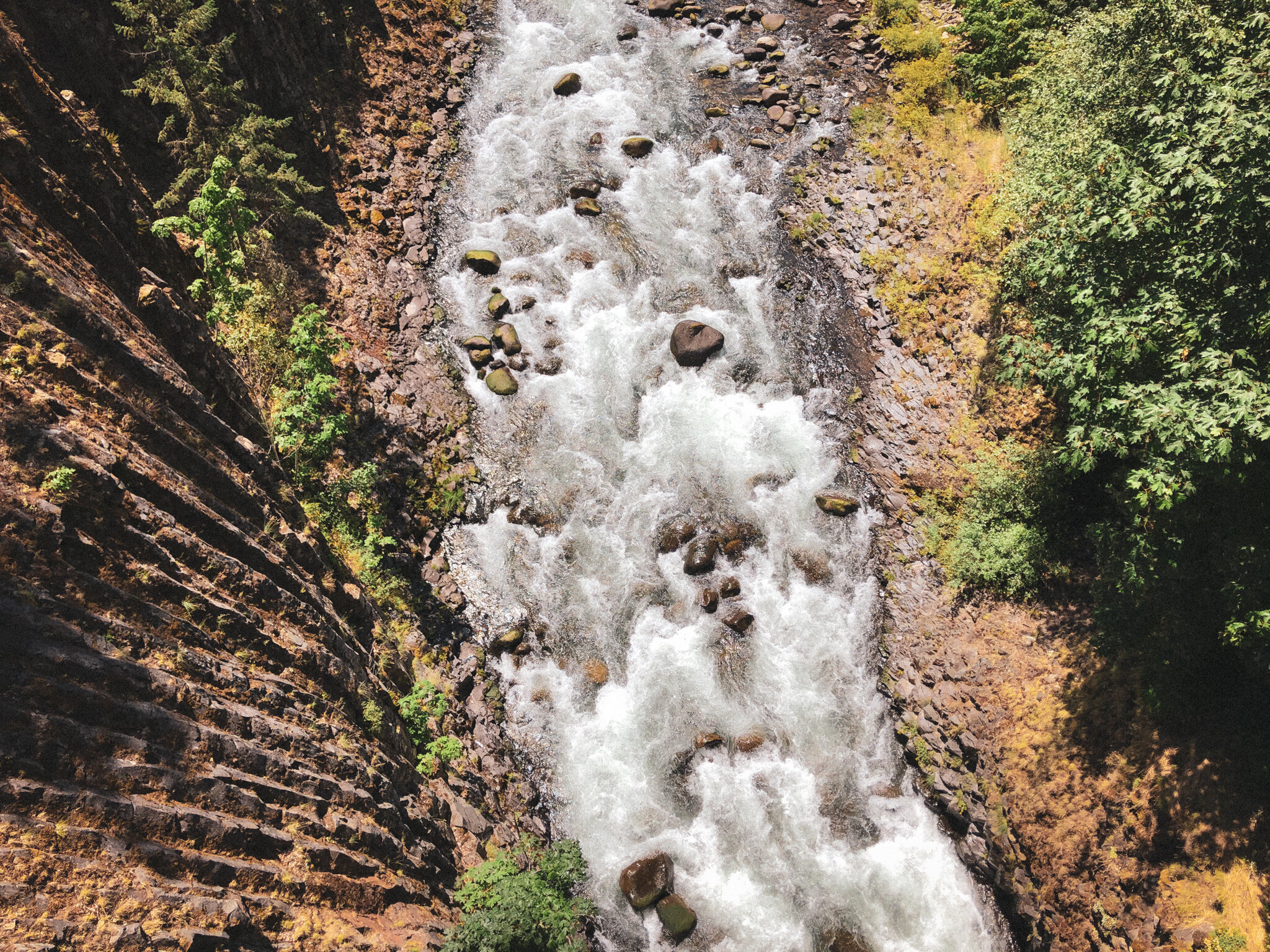

The descent into Dee and the upper valley can be a little spicy, tracing the curvature of the ridge high above the Hood River as it narrows into the basalt-lined slot canyons of Punchbowl Falls. Lower Kingsley intersects Dead Point Creek at mile 23.4, providing an opportune moment to filter water before dropping into the glacier-fed confluence of the east and west forks of the Hood River. This particular ‘Punchbowl Falls’ (one of several so-named throughout Oregon), features 102 public acres of trails lining a precipitous stretch of pristine Chinook and coho salmon habitat and is fishing ground for the Confederated Tribes of the Warm Springs.


From Dee there are a couple of options. The official recommendation is Dee Highway (281) to Trout Creek Ridge, a no muss-no fuss paved beeline straight into Parkdale. We will also call attention to Tony Creek Road on the west side of the river, which happens to be 100% gated and unpaved, goes to exactly the same place only without any cars. It may or may not pass through a parcel of corporate timber land. We’re not saying you should ride it. Simply pointing out that it is there. Ultimately it’s only four miles out of your overall day, so not too big a deal either way.


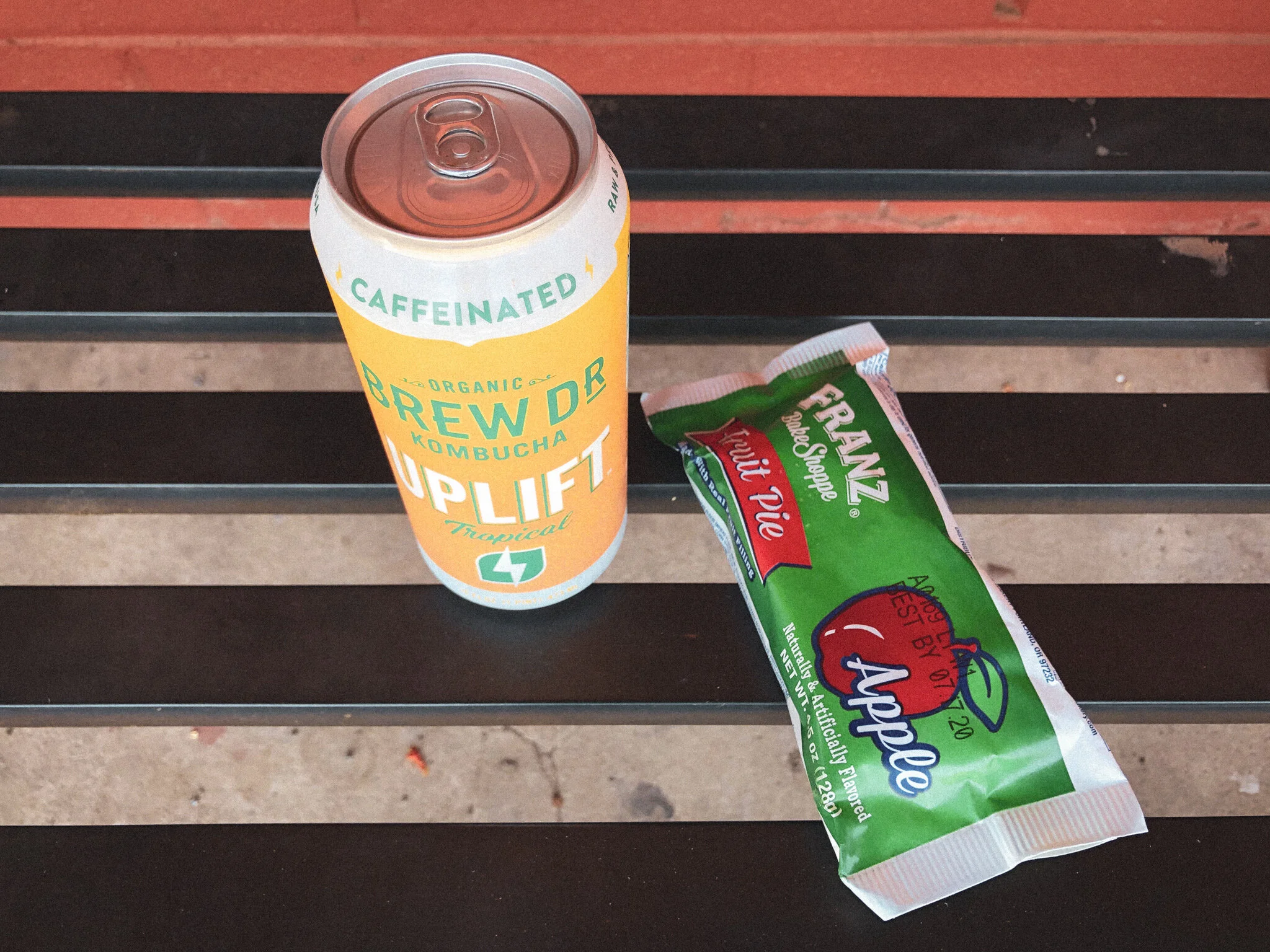
Parkdale, which shows up about midway though the loop, has plenty of good options for lunch and snacks. I’m partial to McIsaac’s Grocery myself (Pro Tip: deli wrap + jalapeño chip special w/ a Brew Dr. and a Franz apple hand-pie…so so good at this stage in the ride), but there is also Apple Valley BBQ and Solera Brewing for dank hazies and even danker mountain views. Be sure to top off all water bottles in Parkdale or Toll Bridge Campground because the Oak Ridge trailhead is 3 short miles up the road and it’s going to be a doozie.
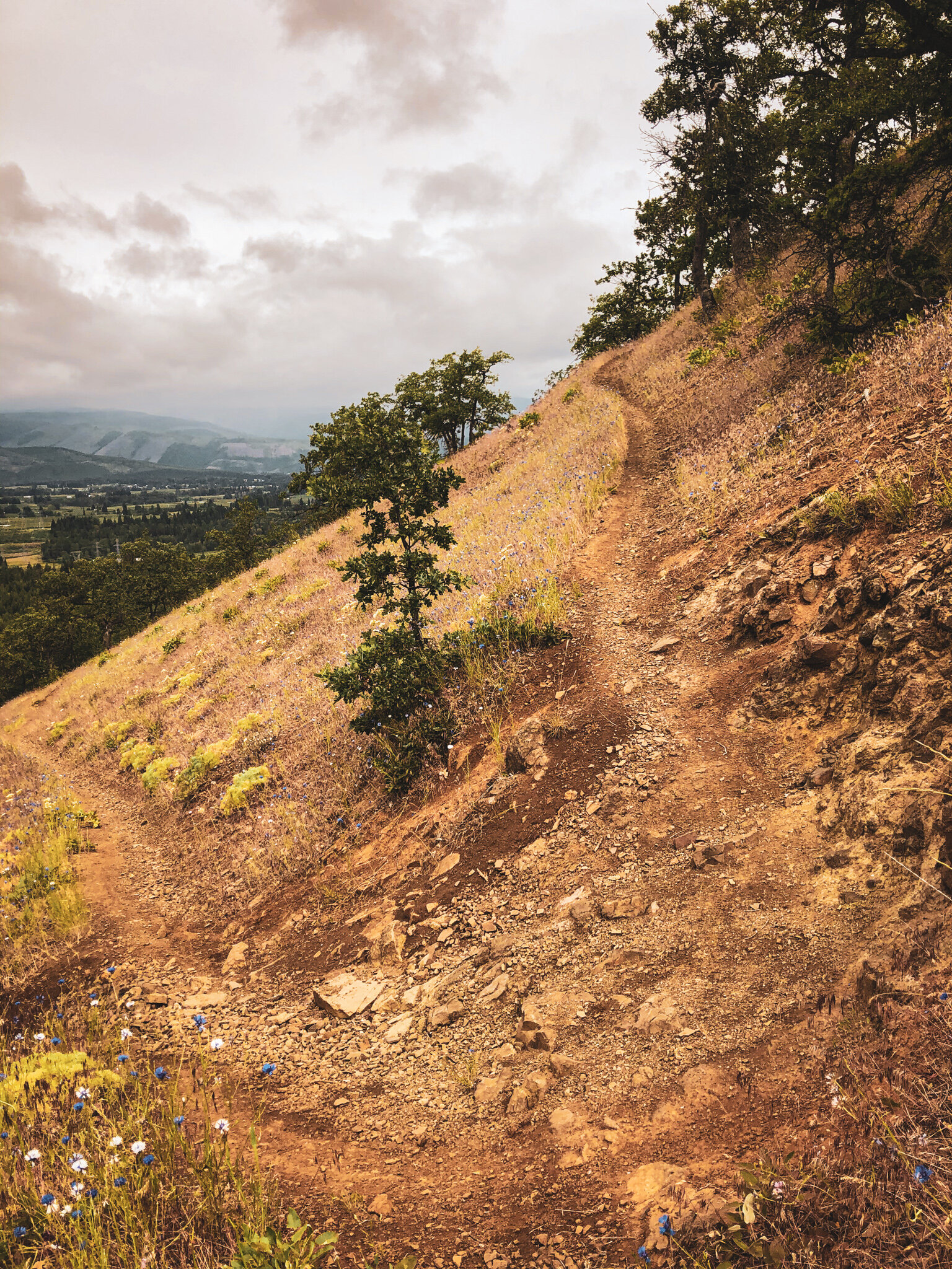
The thing about Oak Ridge is that it climbs about 2000 feet in 2 miles. Ouch. It helps to know that going in. It’s going to be comically steep. It’s going to be comically hard. It is loose, rocky, technical and fully exposed for about half its length, so in the summertime it’s also going to be hot. Did I mention that it happens to be fucking amazing, stunningly beautiful and bears resemblance to the Hospital Hill system above White Salmon. Only nine times harder. Oak Ridge begins modestly enough, rolling gently upward out of the valley through patchy stands of oak and pine, ratcheting up to 13%…14%…15%, emerging from the trees over sunbaked grassy hillsides. 16%…17%…18%…carving absurd lines upward at dizzying angles to top out over 20%. Considering the 26 hairpin switchbacks, give or take, over steep, rutty, loose, technical shale, I would submit Oak Ridge as one of the most challenging climbs you may do all year.
But those valley views?!?


Safely back in the shade, the grades begin to ease, if only just a little. At this end of the spectrum every percentage point seems to make a difference. At least there are trees to lean on, right? Finally at mile 38.5, Oak Ridge climbs out onto a forest access road connecting to Surveyors Ridge. The contrast in gradient between Oak Ridge and the relative normalcy of everything else is disorienting. The legs are a bit wobbly but what a simple joy to be on level-ish ground again. The segment northward out of the National Forest along Surveyors Ridge is short, sweet and rocky, dropping riders out beneath the powerlines into a lawless badland of moto trails. We’d caution against riding the northernmost leg of Surveyors Ridge as it is extremely rutted and blown-out by motorcycle traffic. Instead there is a simple gravel drop down to the tarmac of NF17.


Now we present a choose-your-own-adventure! There are three primary back-end options for the descent into Hood River. Each version stellar in its own way, but we acknowledge having just climbed Oak Ridge, folks may differ on what sounds good at this point. We’ve got Option A: Steep & Chunky Thrillride which punches over to 1710 and drops hard, fast and rowdy along upper Neal Creek. We’ve got Option B: Smooth, Creamy & Dreamy, a veritable pleasure cruise, rolling paved down 17 to descend Booth Hill. And finally we present Option C: the Goldilocks Edition whose terrain sits somewhere in the middle, utilizing a slightly longer gravel combination of 1711, Huskey and Old Dalles to drop back into the north end of the valley.
*Post Canyon + the 44 Trails are built, managed + maintained by the Hood River Area Trail Stewards (HRATS) + the 44 Trails Association respectively. They put in a generous amount of work each season to keep these regional treasures open and running. Please consider donating and volunteering for trailwork events if these systems are on your frequent-ride list.

OPTION A: STEEP & CHUNKY THRILLRIDE
This option is the more direct of the unpaved descents, twisting down into the valley via 1710, which exists in varying condition along a steep 6 mile drop through the Neal Creek drainage. Expect intermittent patches of logging and some comically chunky quarry rock, overall it’s a rowdy blaster of a down. Consider yourself warned. Recommended if you like upper Ketchum and rowdy blasters! Lower 1710 will also have plenty of spots to filter water along Neal Creek before returning to pavement for the final 10 miles. This descent may be a little rough for some, particularly those with narrow or delicate tires.
58.2 MILES
6725 FEET
ROUTE FORMAT: LOOP
SURFACE: 75% UNPAVED, 10% PAVED, 15% SINGLETRACK
TIRES: MINIMUM OF 45C. 2” RECOMMENDED. TUBELESS HIGHLY RECOMMENDED
BIKE: GRAVEL/ADVENTURE/HARDTAIL
WATER FILTER: highly recommended
SERVICES: in parkdale
FULL RIDE WITH GPS ROUTE + GPX FILE
OPTION B: SMOOTH, CREAMY & DREAMY
The creamy & dreamy edition is essentially a paved escape hatch at the end of Surveyors Ridge. From mile 39.8, onward, this smooth backend drops NF17 into Booth Hill, crosses 35 for a minute before rejoining Option A at Eastside Road. Not a bad option for those on slicks, underbiking or who simply want to chillride the orchards back into Hood River.
59.6 MILES
6730 FEET
ROUTE FORMAT: LOOP
SURFACE: 65% UNPAVED, 20% PAVED, 15% SINGLETRACK
TIRES: MINIMUM OF 45C. 2” RECOMMENDED. TUBELESS HIGHLY RECOMMENDED
BIKE: GRAVEL/ADVENTURE/HARDTAIL
WATER FILTER: highly recommended
SERVICES: in parkdale
FULL RIDE WITH GPS ROUTE + GPX FILE
OPTION C: THE GOLDILOCKS EDITION
If A is a bit too rowdy and B is a bit too smooth, consider C juuuuuust right. It is a slightly bigger day, mind you, by about 16 miles and 1000 feet. This one deviates from the others by going up NF17 for a quick hop over to 1711, which rolls until the powerlines, then drops pretty quickly down to Huskey and the Whoopdee zone for a classic meander back into Hood River via Old Dalles. Extra kudos for throwing Whoopdee in the mix on the way back. C’mon, I dare you…
66.6 MILES
7701 FEET
ROUTE FORMAT: LOOP
SURFACE: 75% UNPAVED, 10% PAVED, 15% SINGLETRACK
TIRES: MINIMUM OF 45C. 2” RECOMMENDED. TUBELESS HIGHLY RECOMMENDED
BIKE: GRAVEL/ADVENTURE/HARDTAIL
WATER FILTER: highly recommended
SERVICES: in parkdale
FULL RIDE WITH GPS ROUTE + GPX FILE

Terms of Use: As with each adventure route guide published on OMTM.CC, should you choose to cycle this route, you do so at your own risk.
1. The www.omtm.cc site and @omtm.cc Instagram account (collectively, the “Site”) are owned and operated by Our Mother the Mountain LLC (“OMTM”). The Site is primarily a creative project presented by OMTM and other contributors, but it is increasingly being used as a resource for other cyclists seeking challenging and compelling cycling routes. As such, we want to be clear about what the Site is and is not.
2. It is a creative project and may be used as (a) one resource (of many) for potential routes and (b) a source of inspiration for cyclists.
3. It is not designed to be a replacement for your own diligence and judgment. You should engage in significant additional diligence, and use your judgment regarding the route and your abilities, before embarking on any route described on the Site. You are solely responsible for obeying all public and private land-use restrictions and rules, carrying proper safety and navigational equipment, and following the #leavenotrace guidelines.
4. The information on the Site is for general information purposes only. While we made reasonable efforts to ensure the information was up-to-date and correct when it was posted, the information may be incorrect, incomplete, or outdated. We make no representations or warranties about the completeness, timeliness, accuracy, reliability, or quality of the information. Nor are we able to promise anything regarding weather, route conditions, or route availability. Everything is provided on an “AS IS” and “AS AVAILABLE” basis, and any reliance you place on information available through the Site is at your own risk.
5. Without limiting the foregoing, OMTM is not responsible for GPS content provided by third-party contributors or third-party sites or platforms (such as Discord, Google Groups, and Strava Club) that may be linked or referenced on the Site: we do not own or operate such sites or platforms and are therefore unable to vouch for any content on those sites or platforms.
6. Cycling is an inherently dangerous activity, and we are unable to control the actions of third parties (including without limitation other cyclists or users of the routes). As such, the Site is not designed (or able) to reduce or eliminate your risk of injury, death, or property damage. We assume no responsibility for injury, death, or property damage.
7. You and your heirs, personal representatives, and assigns, agree to indemnify, defend, and hold OMTM, its owner(s), and all OMTM contributors harmless from and against any claims arising out of or related to your use of the Site.