

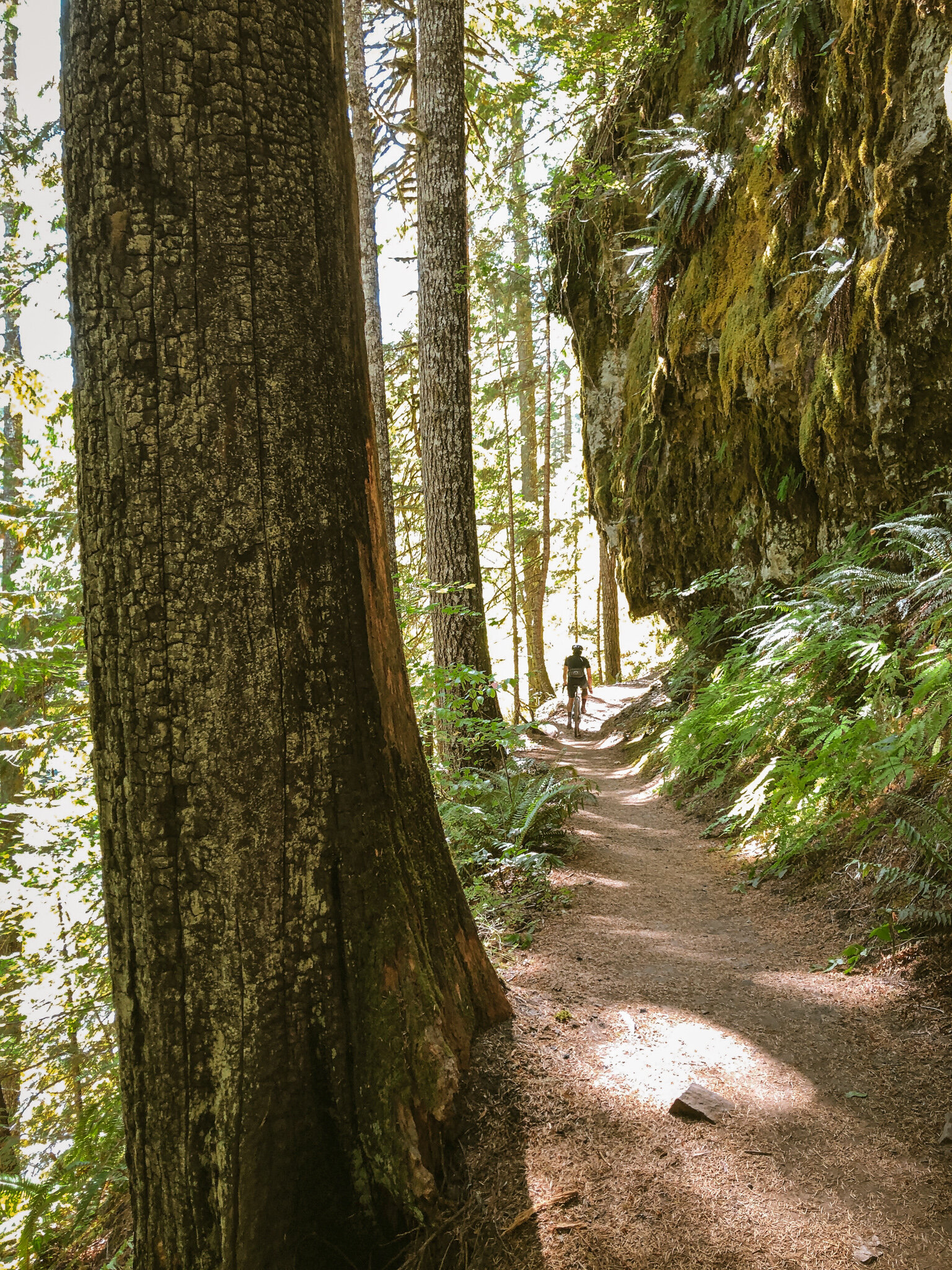
The centerpiece of this phenomenal backcountry loop is the wild, remote and pristine Lewis River valley, whose drainage features ancient stands of mossy old growth forest, enchanting waterfalls, rugged landforms and improbably deep, lush, tranquil swimming holes. Bordering the Dark Divide to the north, Mount Adams and St. Helens to the east and west, the Lone Butte traverses the deep, dank heart of the central Gifford Pinchot.

Help us presage and portend the onset of autumnal splendor in the southern Cascades by experiencing the Lone Butte. The Lewis River Trail No. 31 is the beating heart of the Lone Butte loop, and to get you there we’ve got thirty miles of deep doubletrack descending, virtually car-free, beneath a rich canopy of red alder and vibrant evergreen.
Per established protocol, we offer the Lone Butte in four distinct flavors: Standard Trail, Standard All-road, Extra Light and Endurance Plus. What? No Endurance this time around? Nope. Trust us. Both Standard editions are more than enough to satisfy with 13+ miles of steep, technical and visually idyllic singletrack one one end and a buff 7k of up on the other. Consider as well that all of the primary loops w/ the exception of the Endurance Plus will have V or W-shaped elevation profiles, which as we well know, can really turn up the heat in the final handful of miles.
Do keep in mind that the Lewis River Trail through the waterfall sections (miles 30-34) is a popular day hiking destination, particularly the middle and lower falls areas around the campground. Expect a moderate amount of hikers, families and dogs. Take it easy through this section. Be courteous to other trail users and defer to uphill traffic.


extra light
Make no mistake, the Lewis River Trail No. 31 is the beating heart of the Lone Butte, and to get you there we’ve got thirty miles of deep backcountry descending, virtually car-free, beneath a rich canopy of red alder and valiant evergreen. Be sure to keep your eyes peeled for potholes and patchy pavement along NF90 on the run into the Lewis River Rec Area. The northernmost section of the trail features three iconic waterfalls (upper, middle and lower falls) each with its own sequence of incredible swimming holes. The upper trail itself is relatively smooth and flowing with a handful of exposed technical sections. This edition dips back out to 90 at mile 35 just after the Lower Falls campground, initiating the final 10 mile climb to close the loop.
45.4 MILES
4187 FEET
SURFACE: 70% UNPAVED/DIRT/FOREST ROAD // 20% PAVED // 10% SINGLETRACK
TIRES: 42C PLUS, 47c optimal
BIKE: GRAVEL/ADVENTURE/HARDTAIL
FULL RIDE W GPS ROUTE

standard trail
We consider the Standard Trail the most bang for your buck, provided you like things like pristine backcountry singletrack, impossibly idyllic watercourses and unbridled merriment. Where the Extra Light dips left after the lower falls, the Standard Trail simply crosses 90, picking up the trail again on the other side. The lower trail section (7.7 miles) tends to be steeper, punchier and quite a bit more technical. You will want to understand this going in. Riders would do well to note the tire recommendations and/or consider a hardtail or monster-cross (2.1” plus) setup for this edition. The trail will burn a lot of matches. Take care to pace yourself. This version simply picks up NF90 again from the bottom near Curly Creek, climbing 3211 back up to the Lone Butte Sno-Park.
53.8 MILES
5157 FEET
SURFACE: 50% UNPAVED/DIRT/FOREST ROAD // 20% PAVED // 30% SINGLETRACK
TIRES: 47C PLUS. 2.1” optimal
BIKE: GRAVEL/ADVENTURE/HARDTAIL
FULL RIDE W GPS ROUTE


standard all-road
So maybe trails aren’t your thing. You’re more of a grabble-grinder or backcountry rambler, well we’ve got you covered! The Standard All-road shares the same front-end with the others, sidestepping the trail at mile 30 in favor of a nice steady trundle up over Spencer Butte, Platinum Creek and Breezy Point. You think I’m making those names up? Not a chance. Strap yourself in for an ultra-mega 2300 foot descent from Spencer Peak down to Curly Creek, crossing the Lewis River once again at mile 60, rejoining the other routes for the remaining climb out.
70.8 MILES
7410 FEET
SURFACE: 60% UNPAVED/DIRT/FOREST ROAD // 40% PAVED
TIRES: 40C PLUS, 47c optimal
BIKE: GRAVEL/ADVENTURE/HARDTAIL
FULL RIDE W GPS ROUTE


endurance plus
This one’s for the overachiever. Got them twitchy legs yearnin’ for some burnin’? Level up to the Endurance Plus and show ‘em you’re a tiger. The Endurance Plus rolls the Historic Highway out to Cascade Locks via the State Trail, crossing Bridge of the Gods up through Carson. Ever wanted to take the Panther Creek line to its logical conclusion? Here’s your chance. In this case we roll NF65 all the way up to the Lone Butte Sno-Park, do the Standard Trail line, only instead of climbing back to Lone Butte after the singletrack, here we hit the escape hatch out to 90 through Cougar, Yacolt and Moulton Falls in a southerly fashion across the 205 bridge and back into town.
205.2 MILES
14952 FEET
SURFACE: 70% paved // 25% UNPAVED/DIRT/FOREST ROAD // 5% singletrack
TIRES: 40C PLUS, 47c optimal
BIKE: GRAVEL/ADVENTURE/HARDTAIL
FULL RIDE W GPS ROUTE


Terms of Use: As with each adventure route guide published on OMTM.CC, should you choose to cycle this route, you do so at your own risk.
1. The www.omtm.cc site and @omtm.cc Instagram account (collectively, the “Site”) are owned and operated by Our Mother the Mountain LLC (“OMTM”). The Site is primarily a creative project presented by OMTM and other contributors, but it is increasingly being used as a resource for other cyclists seeking challenging and compelling cycling routes. As such, we want to be clear about what the Site is and is not.
2. It is a creative project and may be used as (a) one resource (of many) for potential routes and (b) a source of inspiration for cyclists.
3. It is not designed to be a replacement for your own diligence and judgment. You should engage in significant additional diligence, and use your judgment regarding the route and your abilities, before embarking on any route described on the Site. You are solely responsible for obeying all public and private land-use restrictions and rules, carrying proper safety and navigational equipment, and following the #leavenotrace guidelines.
4. The information on the Site is for general information purposes only. While we made reasonable efforts to ensure the information was up-to-date and correct when it was posted, the information may be incorrect, incomplete, or outdated. We make no representations or warranties about the completeness, timeliness, accuracy, reliability, or quality of the information. Nor are we able to promise anything regarding weather, route conditions, or route availability. Everything is provided on an “AS IS” and “AS AVAILABLE” basis, and any reliance you place on information available through the Site is at your own risk.
5. Without limiting the foregoing, OMTM is not responsible for GPS content provided by third-party contributors or third-party sites or platforms (such as Discord, Google Groups, and Strava Club) that may be linked or referenced on the Site: we do not own or operate such sites or platforms and are therefore unable to vouch for any content on those sites or platforms.
6. Cycling is an inherently dangerous activity, and we are unable to control the actions of third parties (including without limitation other cyclists or users of the routes). As such, the Site is not designed (or able) to reduce or eliminate your risk of injury, death, or property damage. We assume no responsibility for injury, death, or property damage.
7. You and your heirs, personal representatives, and assigns, agree to indemnify, defend, and hold OMTM, its owner(s), and all OMTM contributors harmless from and against any claims arising out of or related to your use of the Site.