

At what point does a route become a staple - one that lures you back, year after year, in all seasons and conditions? I find there exists a special subset of adventures that inspire innumerable repeat visits, each revealing something new and unexpected. chenoweth tableland ranks among the select few comfort loops I am continually excited to share with friends, one that keeps us coming back, inspiring subtle variants and exploratory offshoots with every visit.

We all have our comfort loops. By that I mean the usual haunts and old favorites; familiar zones often revisited when you don’t feel like fussing with a plan. There is a peculiar liberation in leaving the GPS at home, content with the spontaneity of rolling a la carte. The Mosier-Dalles continuum is one such area for us. We’ve ridden just about everything worth riding in, around, above and between those two locales and will submit this as quite possibly the best bang-for-your-buck betwixt them both.
Okay, so maybe you’ll still need your GPS.
Chenoweth Tableland just checks all the right boxes - it is concise, punchy and fantastically engaging within only 42 miles. This one trots out the hits in short order - plush climbs, technical singletrack, mysterious eagle caves, magical double-mountain sightlines, illicit 4x4 grades, microclimates galore…hold on - let me catch my breath… rocky cliffside vistas, cutty neighborhood trails, secret riverside beaches, roadside swimming holes and the subtly spectacular and ultra-photogenic Rowena curves. It is also generally accessible year round.


The Mosier-Dalles-Rowena nexus is ripe with all kinds of nested secrets. As we’ve mentioned more than a few times, Mosier is one of our favorite jump-offs in the central-eastern Gorge. It serves as a convenient hub from which many distinct micro-regions are accessible. Because this loop is well-traveled for us, we opt for a leadout of least resistance and most fun - a beeline up Dry Creek to the top of Vensel via Osborn Cutoff. One can choose from a handful of alternate lines to the same spot, all of them fine, most of them harder, steeper and more roundabout. Like I say, this line is all about getting to the goods quickly.
That said, Vensel Road is not without its 12% pitchy bits. Never fear, it is nothing too long or arduous and it is always stunning in any weather. While the punchy bits hurt a little, gradients eventually ease, rambling ever upward to intersect Ketchum and Chenoweth Roads. Those familiar with our oeuvre will recognize this junction from the Super G, Dirty Ketchum and Mosier Mayhem routes. Easing up toward the hump on Chenoweth is a sensation not unlike rounding the apex of a roller-coaster…waiting for the drop.


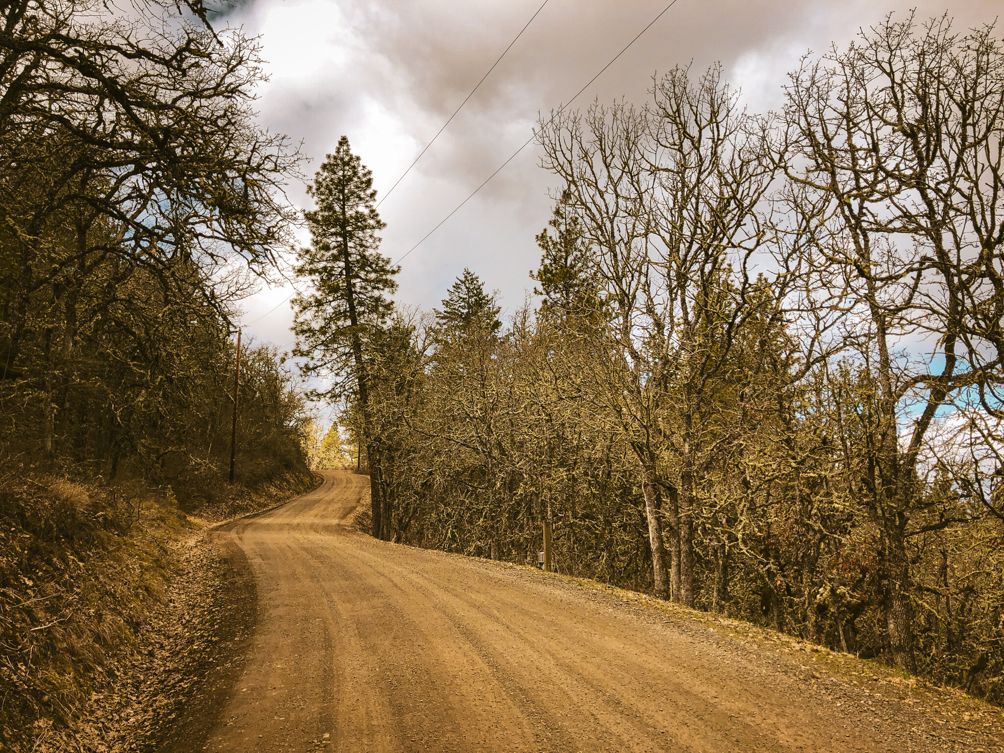
And drop it does! Descending into Chenoweth, expect a thrillride of chunky lines, hairpin corners and runoff-ruts up top, gradually smoothing into manicured farm gravel and ultimately pavement below. Be aware that folks have often encountered dogs running out into the road from the houses at the bend (mile 12.1). A sharp guttural NOOO and hearty sprint work in a pinch, so keep on your toes. Other than that, it is all buttery smooth up through Browns Creek to the hard left climb into Wahtonka Road, which can be easy to miss.


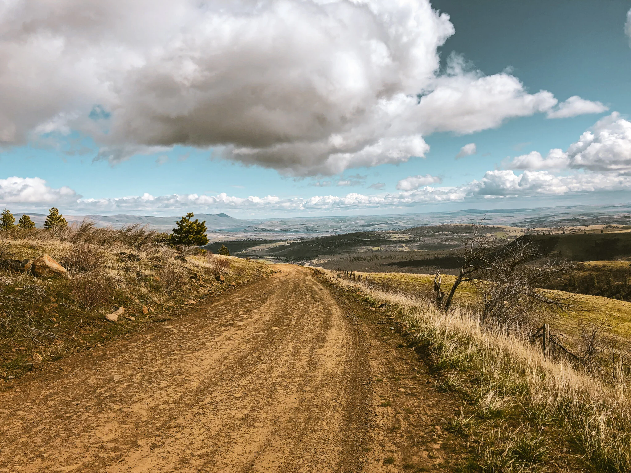
At first glance, Wahtonka doesn’t feel right, two private ranch driveways immediately peel off to either side leaving a rutted-out primitive Jeep trail in the center. Our line runs up the middle, steep and chunky for almost a mile, rounding a rutted hairpin turn to the right. We’ve had dog issues at the house just after the final turn, so again be prepared for the possibility of dogs and testy locals, but keep in mind that this is public right of way. Wahtonka>Sandlin>Archery Road delivers riders efficiently to the Chenoweth Tableland trailhead(s). This deceptively flat sandstone plateau and cliff complex, remains of a pliocene-era lakebed, encompasses 300 acres of public Forest Service land crisscrossed by trail networks and meandering primitive doubletrack. From the plateau one quickly forgets the entire city sprawling just below the horizon.


While there’s no wrong way to explore the plateau, ultimately there are two main approaches accessing the sandstone cliffs, east rim trails and the iconic eagle caves. The officially recommended line will be the Archery Rd trail to Eagle Caves trail.
Straight. Easy. No muss. No fuss.
We’ll also put out there that a slightly more roundabout (read sketchier) line exists if you know where to look. This involves a bit of fence-hopping, gametrail poaching and stuff you won’t want any part of. Check the heatmaps if you’re curious. Not recommending anyone trespass. Just pointing out the trails are there. Take care to note the plateau, being a plateau, does not drain particularly well, so tends to be pretty boggy in the rainy season, late fall through early spring.


The Eagle Caves trail rambles the rim north along rugged sandstone cliffs with panoramic sightlines across the Dalles from Lyle to Maryhill and well beyond on a clear day. At the north end, the trail drops into a steep notch where you’ll find the eagle caves and Upper Bench trail.
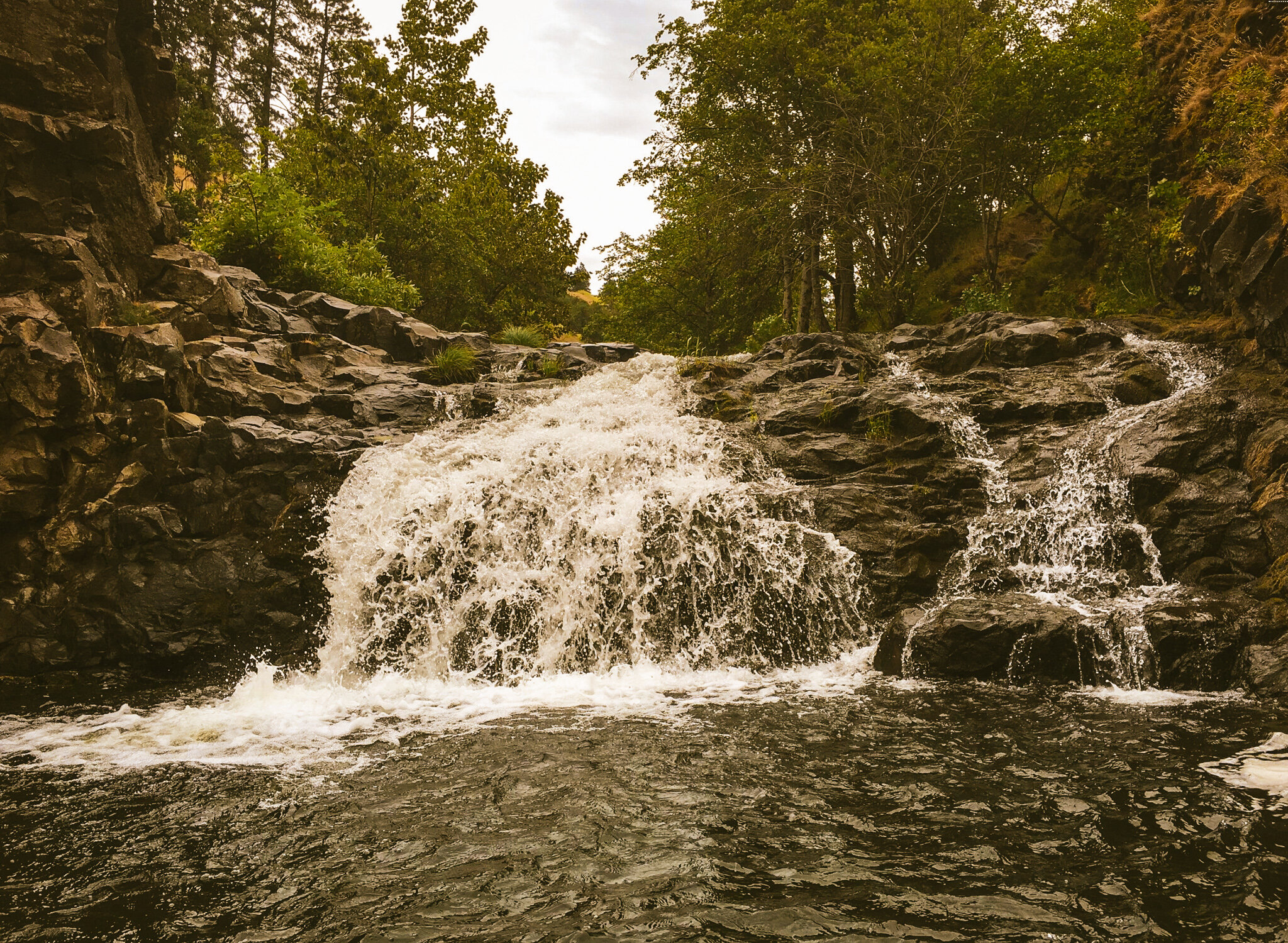
The caves themselves are certainly worth a visit, but Forest Park this is not. More of a high school party spot than pristine nature preserve, the eagle caves are frescoed with teenage graffiti several generations deep. From here, we pick up the Upper Bench trail westward, the uppermost of three stepped trails running laterally along the oaky bench below the plateau rim. The Upper Bench singletrack traces the arc of the plateau through exposed outcroppings, intermittent watercourses and rippling drainages, dropping into a wide grassy basin via the fabled Chenoweth ‘gnarcarpets’ (so named for the close-cropped grassy, carpet-like character of the trails) intersecting both the Rock Gulch Run and Waterfall trails. These trails can, of course, be configured according to preference, but we keep coming back to the sequence of Upper Bench - Waterfall - Middle Bench to maximize time on the trails. It gets a bit confusing on the southwest end where a tangle of unmarked lines converge, but the idea is to find your way along the Middle (or Lower) Bench out to the northernmost point of the ridge where the bench trails merge, dropping out through a gate behind the old Chenoweth Middle School. This makes a good rally point if riders become separated through the bench trails.


The adventure continues via cutty neighborhood trail circuits running beneath the base of the cliffs. There are plenty of offshoots through this section, most leading down into the neighborhoods, so when in doubt, take the higher line which ultimately runs its course along backyard fencelines through to Chinook Street. From here it’s just a bit of crosstown ramble over to Webber, which is one of the few Dalles arterials that dip beneath highway 84 to access the city’s industrial east side.


The Dalles’ waterfront is predominantly industrial with the exception of a narrow Riverfront Trail lining the rocky edge of the Columbia. Our route picks up the Riverfront Trail next to the Bargeway Pub. Beer and food conveniently positioned at the halfway point in the loop makes a compelling case for a quick stop. The paved river trail winds north along rocky coulees, amid heavy industrial equipment, rusting barges and quiet river vistas. Beyond the massive Google data complex, the trail bypasses the high-traffic coal-rolling north end of The Dalles in favor of a meandering course through native dip-net fishing platforms with networks of smaller trails leading to clandestine beaches. The Riverfront Trail ultimately connects with the Historic Highway near the Columbia Gorge Discovery Center and Museum.


CELILO FALLS
On March 10, 1957, the massive steel and concrete floodgates of newly completed The Dalles Dam on the Columbia River are drawn closed, and within hours Celilo Falls, approximately 13 miles upstream, between Wishram and Celilo Village, disappears beneath the rising waters. The falls formed a rough horseshoe shape across the river, and nearby are two ancient Native villages -- Wyam, on the Oregon side of the river, and S'kin on the other shore -- which also disappear into the reservoir behind the dam. Tribes from near and far have for thousands of years come here to fish, trade, and socialize, and the loss of the falls and downstream waters is a heavy blow to traditional Native culture. Tribal members are among the 10,000 people who gather to witness the opening of the dam and the submergence of Celilo Falls, considered by most a heartbreaking turning point.


As a point of historical fact, we recognize that these lands are unceded ancestral territories of Sehaptin speaking peoples. To put this into perspective, the region was incorporated as a U.S. territory in 1848 yet existed since time immemorial as trading, fishing and hunting grounds of the Molala, Tenino, Yakama, Wasco and Wishram tribal peoples.
Between Celilo Falls and Priest Rapids, there existed a cross-section of peoples, not a single tribe so much as myriad autonomous groups, speaking the Sahaptin language. Downriver from Celilo were the Wasco-Wishrams, who spoke a Chinookan language. Each language had its own particular subdivisions. Upper Chinook, for instance, is a series of individual languages and dialects ranging from the Oregon and Washington coasts to the middle Columbia River Gorge. There was a Cascades dialect separate from the Wasco-Wishrams, and subtle differences even between those two groupings. All these peoples shared the river in common, primarily because of the tremendous natural resource it provided in the annual salmon runs. The salmon were - and are - more than a food source; they're a link between mankind and creator, symbol of an ancient lifestyle maintained always close to the earth.


For the most part, Sahaptin speakers followed the way of life characteristic of Plateau Indians. The Plateau culture area lies between the Rocky Mountains and the coastal cordillera and is characterized by semiarid region of sagebrush, grass, and scattered pine groves that are interwoven with rivers and streams containing plentiful salmon and other fish. Thus, the Plateau peoples had an unusually reliable food supply for desert dwellers. They also hunted such game as deer and gathered a variety of wild plant foods.
The western Sahaptin tribes, including the Molala, Tenino, and Yakama, avoided formal political structures. The primary political unit was the autonomous village composed of a band of related families. These groups typically allied together during times of war and otherwise remained independent. The eastern tribes, including the Nez Percé, Palouse, Cayuse, and Umatilla, were heavily influenced by the Plains Indians with whom they traded on seasonal journeys across the Rockies. They developed relatively strong political cohesion for Plateau tribes, with a tribal chief and council.

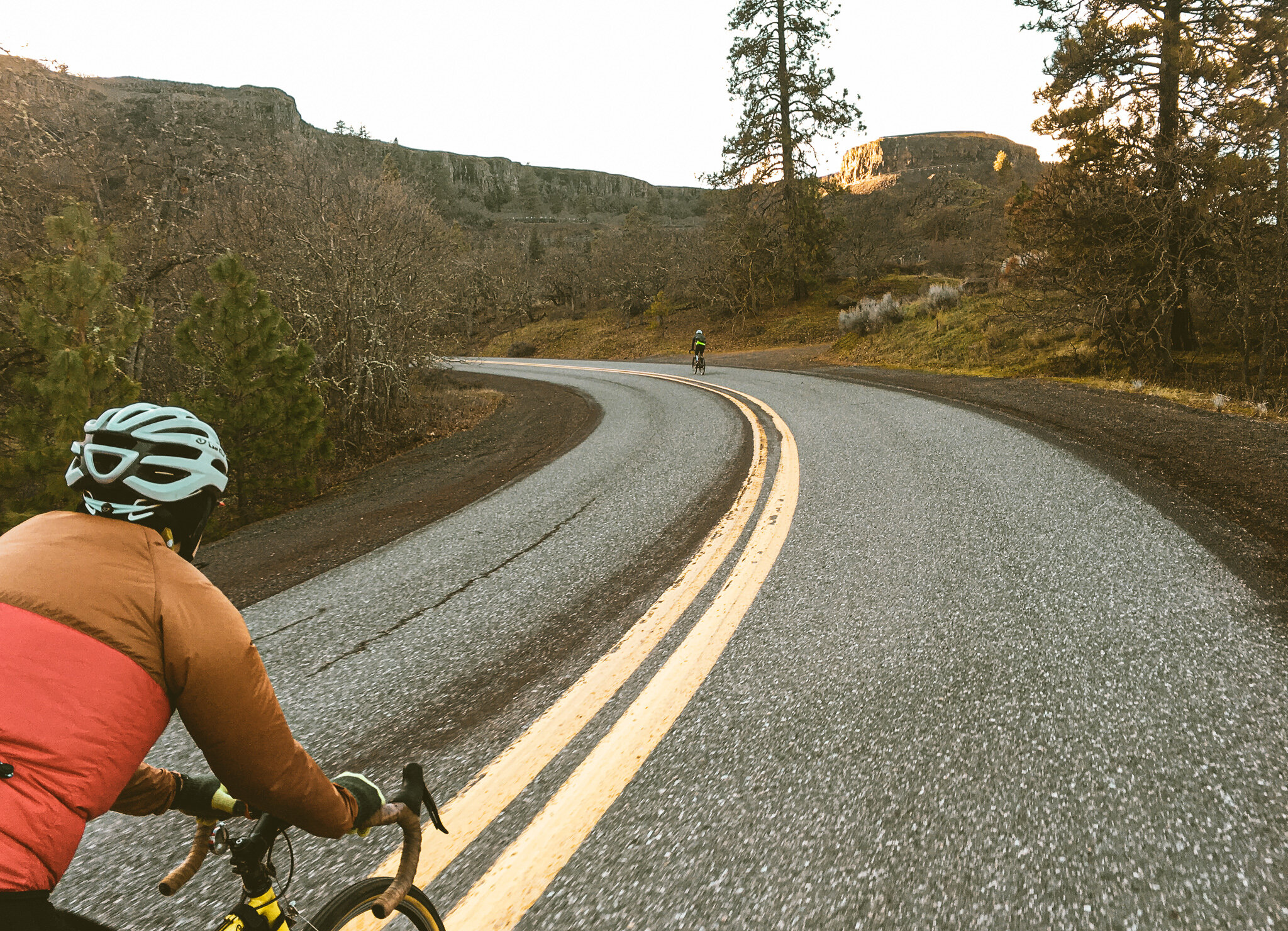
It is a fairly gentle gradual climb up through Rowena Crest and back into Mosier via the Historic Highway. Chances are if you’re reading this you will be familiar with this stretch, if not, consider yourself fortunate to be able to ride it for the first time.
While the basic routing simply rolls Highway 30 13 miles back in, there are several elective adventure-lines back to Mosier, each with their own distinct flavor. Dell Road’s punchy gravel climb works as does Marsh Cutoff, the former with its own sequence of sidetrail adventures along the abandoned Mosier airstrip, the latter more of a standard paved affair. Additionally, from the Highway 30 side, there is an extra-credit climb up to the Mosier plateau radio towers. It is punchy, chunky and steeper than you’re probably looking for, but it’s a fun, weird perspective on the area that drops down the slightly poachy, rough and tumble back side of the plateau. All of these options ultimately end up on State Rd, where if one knows where to look, one might find a goatpath down to Mosier swimming hole, which is highly recommended in the summertime, if even just to dip your cap.


42 MILES
3986 FEET
ROUTE FORMAT: LOOP
SURFACE: 50% GRAVEL, 40% PAVED, 10% SINGLETRACK
TIRES: MINIMUM OF 42C
SERVICES: MOSIER + THE DALLES
ROUTE DETAILS
As a course of post-ride habit, MoCo is virtually the only game in town. I typically tuck into the fresh-baked pretzel with bierkase or loaded nachos with house-made pickled vegetables. Sometimes both if I’m feeling saucy. RIYL hearty contempo NW comfort food, a well-curated local tap list and spacious patios with firepits.
New to town is Randonnée Coffee, a 10 Speed Roasters offshoot, serving artisanal-grade espresso and pastries from Lewis Fitzgerald. Adjacently located is the new Taqueria Chapalita, which I have yet to try, but my hunch is they’re doing it right.


Terms of Use: As with each adventure route guide published on OMTM.CC, should you choose to cycle this route, you do so at your own risk.
1. The www.omtm.cc site and @omtm.cc Instagram account (collectively, the “Site”) are owned and operated by Our Mother the Mountain LLC (“OMTM”). The Site is primarily a creative project presented by OMTM and other contributors, but it is increasingly being used as a resource for other cyclists seeking challenging and compelling cycling routes. As such, we want to be clear about what the Site is and is not.
2. It is a creative project and may be used as (a) one resource (of many) for potential routes and (b) a source of inspiration for cyclists.
3. It is not designed to be a replacement for your own diligence and judgment. You should engage in significant additional diligence, and use your judgment regarding the route and your abilities, before embarking on any route described on the Site. You are solely responsible for obeying all public and private land-use restrictions and rules, carrying proper safety and navigational equipment, and following the #leavenotrace guidelines.
4. The information on the Site is for general information purposes only. While we made reasonable efforts to ensure the information was up-to-date and correct when it was posted, the information may be incorrect, incomplete, or outdated. We make no representations or warranties about the completeness, timeliness, accuracy, reliability, or quality of the information. Nor are we able to promise anything regarding weather, route conditions, or route availability. Everything is provided on an “AS IS” and “AS AVAILABLE” basis, and any reliance you place on information available through the Site is at your own risk.
5. Without limiting the foregoing, OMTM is not responsible for GPS content provided by third-party contributors or third-party sites or platforms (such as Discord, Google Groups, and Strava Club) that may be linked or referenced on the Site: we do not own or operate such sites or platforms and are therefore unable to vouch for any content on those sites or platforms.
6. Cycling is an inherently dangerous activity, and we are unable to control the actions of third parties (including without limitation other cyclists or users of the routes). As such, the Site is not designed (or able) to reduce or eliminate your risk of injury, death, or property damage. We assume no responsibility for injury, death, or property damage.
7. You and your heirs, personal representatives, and assigns, agree to indemnify, defend, and hold OMTM, its owner(s), and all OMTM contributors harmless from and against any claims arising out of or related to your use of the Site.