


Drainage patterns are created where watercourses follow the lead of the landscape’s geological history, features and contours. Characteristics of the underlying rock, steepness of slope, faults and joints in the Earth’s surface, the specific shape of particular geological formations, and the soil’s susceptibility to erosion are among the factors that affect the pattern established for the flow of water through a particular place.

Following the Molalla River upstream is a bittersweet journey into a watershed haunted by its elemental, geological and cultural history. From the alluvial bottomlands of the Willamette Valley, the Molalla basin can be traced far upriver into the rolling uplands of the Table Rock plateau. The river in fact, has no single, definitive source, rather it is the accumulated drainage of a broad and vascular network of springs, creeks, streams and minor watercourses. Its north and south forks define the boundaries of the Table Rock Wilderness, converging into the mainstem Molalla near the site of the Old Bridge trailhead, thus creating the largest unregulated tributary feeding into the Willamette.
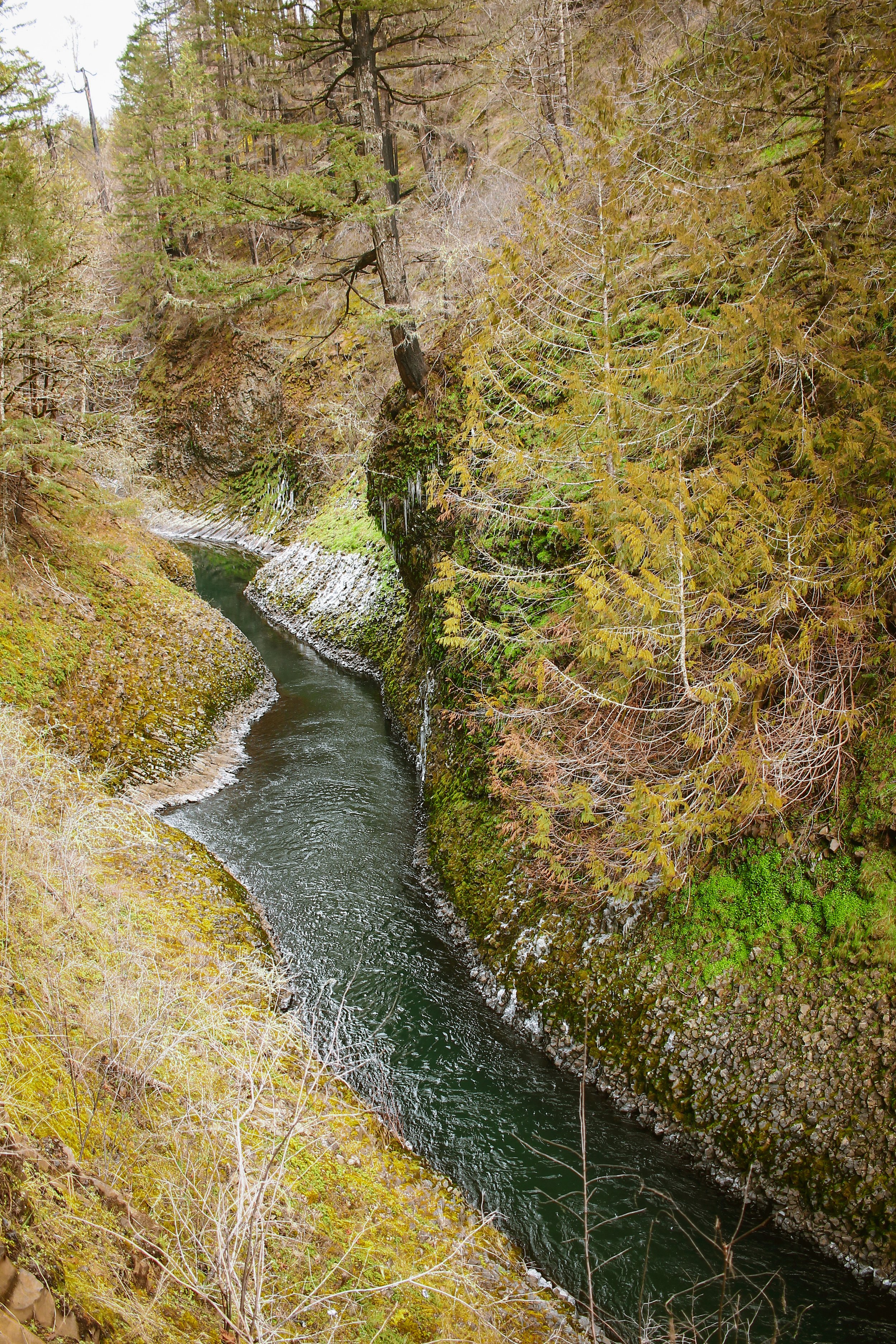
The Molalla finds its form beneath the transitional foothills of Gawley Ridge, having incised steep, narrow canyons through Columbia River basalt flows, Pleistocene-era bedrock, Miocene and Oligocene volcanic tuff, andesite and breccia, leaving behind columnal pillars, dramatic outcrops and circular rosette formations — geology as iconically Oregonian as it is alien and severe. The Molalla landforms feel characteristically similar to those of the Columbia River Gorge having been forged by the same dynamic intersection of ancient volcanics and flowing water.


Ancestral Trails
Trails along the Molalla River have existed for millennia as part of a sprawling circuit of trade routes and seasonal foraging encampments used by Northern Molalla, Crooked Finger Molalla and Santiam Band Molalla peoples. Kindred spirits with the Klamath peoples, the Molalla’s seasonal highways connected their homelands in the Willamette Valley to the Western Cascadian high country and beyond to Warm Springs and south to the McKenzie River drainage.


The best documented aspect of Molalla culture is the language through which it was transmitted. From the mid-nineteenth century into the twentieth, a succession of scholars transcribed samples of spoken Molalla from a people known to anthropologists as the Northern Molalla and known to themselves as the Latiwi or Lati-ayfk people. Molalla was formerly classified as part of the so-called Waiilatpuan language family, together with the Old Cayuse language (the language spoken by the Cayuse people of northeastern Oregon and southeastern Washington in the early nineteenth century). Linguists have since concluded that Molalla shares a remote common ancestry with other languages of the same region, especially with the neighboring Sahaptin, Nez Perce and Klamath languages.
Crooked Finger
Loshuk, a Molalla Chief also known as Crooked Finger, lived in an upland valley in the foothills of the Abiqua basin. The area is called Crooked Finger Prairie to this day. Loshuk is said to have received his American name Crooked Finger when as a boy he was playing with a rifle and it went off, disfiguring his hand. In his time he was renowned for speaking against the American settlement of his land and set about to harass settlers and homesteaders whenever he could as partial retribution for the losses his people were sustaining.

Beachie Creek Fire
In August of 2020, at the peak of a brutal summer heatwave, lightning ignited a wildfire in the heart of the remote and rugged Opal Creek Wilderness, home to the largest stretch of unlogged, old-growth forest remaining in Oregon. Accelerated by a historic windstorm, the Beachie Creek fire raced explosively up and down the canyons, tearing through wilderness and timberland alike, burning nearly 200,000 acres before merging with the massive Lionshead fire to create the Santiam fire complex, which ultimately exceeded 400,000 acres before being contained in December of 2020.
As with many of the 2020 Oregon wildfire zones, most of the affected areas have been closed to public entry ever since, locked away within controlled closure perimeters while salvage logging operations remove debris and downed trees as well as clearing landslides, rocks and other hazards from key arterials. That said, progress is slow and many of the affected areas are likely to remain closed for the foreseeable future.


Route Overview
The Molalla Headwaters route features a handful of anomalies. The first being that it is 100% paved. The second curious feature and centerpiece of the experience, is a 12-mile out-and-back stretch (24 miles round trip) along the Molalla River corridor in and out of the burn, which ventures inside the fire perimeter to the edge of the current closure.
Crossing the line from lush river valley into the spectral forest of a catastrophic burn is an unsettling sensation. The usual forest sounds of rustling leaves, birdcalls and rushing water seem somehow muted by an overwhelming presence of ash, rock, dust and charred debris.

One may also notice seemingly odd temperature inversions. The northernmost section of this out-and-back line runs through a narrow, densely forested canyon with steep walls which reflect and insulate a corridor of cold air coming off the river, but incidentally the roadbed diverges from the river as it climbs, crossing to the east bank at the burn perimeter. Distance from the river, coupled with an abrupt lack of shade or insulating vegetation will oftentimes cause microclimatic spikes and drops in temperature. Our accounts registered 42 in the canyon jumping to 62 as we crossed into the burn, and vice-versa on the way back out.
We will stop short of claiming the Molalla River is haunted, but there is definitely some peculiar mojo back in this valley. A series of freshwater springs noted within the route flow directly out of the hillside at mile 37.8, providing plenty of natural water refill. As with certain other routes within this series, rather than starting from a common point, the different variants are distinguished by their start/finish locations.


While we opted to keep the Molalla River Headwaters a fully paved ride, those looking for a bit of a deeper adventure would do well to note the extensive and fully bike-legal trail system which runs along the west side of the Molalla corridor. Rather than call out specific trails or lines, we’ll simply note that they are there if folks feel like exploring a little deeper and further afield.


EXTRA-LIGHT
47 MILES
3699 FEET
ROUTE FORMAT: LOOP with out-and-back tail
SURFACE: 100% PAVED
TIRES: 28c road tires
SERVICES: FOOD AND DRINK OPTIONS AVAILABLE IN molalla
ROUTE DETAILS
STANDARD
86.1 MILES
6404 FEET
ROUTE FORMAT: LOOP with out-and-back tail
SURFACE: 100% PAVED
TIRES: 28c road tires
SERVICES: FOOD AND DRINK OPTIONS AVAILABLE IN molalla
ROUTE DETAILS
ENDURANCE
110.9 MILES
7829 FEET
ROUTE FORMAT: LOOP WITH OUT-AND-BACK TAIL
SURFACE: 100% PAVED
TIRES: 28C ROAD TIRES
SERVICES: FOOD AND DRINK OPTIONS AVAILABLE IN PORTLAND, MOLALLA AND BARTON
ROUTE DETAILS
Terms of Use: As with each adventure route guide published on OMTM.CC, should you choose to cycle this route, you do so at your own risk.
1. The www.omtm.cc site and @omtm.cc Instagram account (collectively, the “Site”) are owned and operated by Our Mother the Mountain LLC (“OMTM”). The Site is primarily a creative project presented by OMTM and other contributors, but it is increasingly being used as a resource for other cyclists seeking challenging and compelling cycling routes. As such, we want to be clear about what the Site is and is not.
2. It is a creative project and may be used as (a) one resource (of many) for potential routes and (b) a source of inspiration for cyclists.
3. It is not designed to be a replacement for your own diligence and judgment. You should engage in significant additional diligence, and use your judgment regarding the route and your abilities, before embarking on any route described on the Site. You are solely responsible for obeying all public and private land-use restrictions and rules, carrying proper safety and navigational equipment, and following the #leavenotrace guidelines.
4. The information on the Site is for general information purposes only. While we made reasonable efforts to ensure the information was up-to-date and correct when it was posted, the information may be incorrect, incomplete, or outdated. We make no representations or warranties about the completeness, timeliness, accuracy, reliability, or quality of the information. Nor are we able to promise anything regarding weather, route conditions, or route availability. Everything is provided on an “AS IS” and “AS AVAILABLE” basis, and any reliance you place on information available through the Site is at your own risk.
5. Without limiting the foregoing, OMTM is not responsible for GPS content provided by third-party contributors or third-party sites or platforms (such as Discord, Google Groups, and Strava Club) that may be linked or referenced on the Site: we do not own or operate such sites or platforms and are therefore unable to vouch for any content on those sites or platforms.
6. Cycling is an inherently dangerous activity, and we are unable to control the actions of third parties (including without limitation other cyclists or users of the routes). As such, the Site is not designed (or able) to reduce or eliminate your risk of injury, death, or property damage. We assume no responsibility for injury, death, or property damage.
7. You and your heirs, personal representatives, and assigns, agree to indemnify, defend, and hold OMTM, its owner(s), and all OMTM contributors harmless from and against any claims arising out of or related to your use of the Site.