

You don’t have to look far to find the goods in the Methow. The inner Valley’s honeytoned foothills and bristling highlands pack big views and a stunning diversity of terrain. The Canyons, Coulees & Cowbells loops trace the rippling hillsides above Pearrygin Lake through Pipestone Canyon’s undulant sagebrush and dirt-track rollers, closing the circuit with a robust sampling of Sun Mountain’s frontcountry flavor, recovering burn zones and golden bunchgrass prairie.

While these route variations were originally created for the 2024 Lost Weekend: Methow Valley, the beauty is that they never really go away. The routes live on for anyone to experience at any time. The Canyons, Coulees & Cowbells loops are particularly appealing because they stay relatively close in but feel quite remote. By close in, I mean they never push into the backcountry per se, yet still manage to pack in a dynamic progression of singletrack, gravel, community trail and rustic doubletrack that is never too far from a leisurely lunch stop in Twisp.


Pearrygin Lake
Pearrygin Lake State Park’s 11 miles of multi-use trails offer panoramic sightlines of the Valley’s iconic sagebrush meadows and clustered pine forests. The Rex Derr trail’s meandering hillside lines gently trace contours of classic shrub-steppe through open meadow and pockets of forest, in and out of the treeline before climbing into the higher elevations of the Methow Winter Range and Wildlife Refuge.
Pipestone Canyon
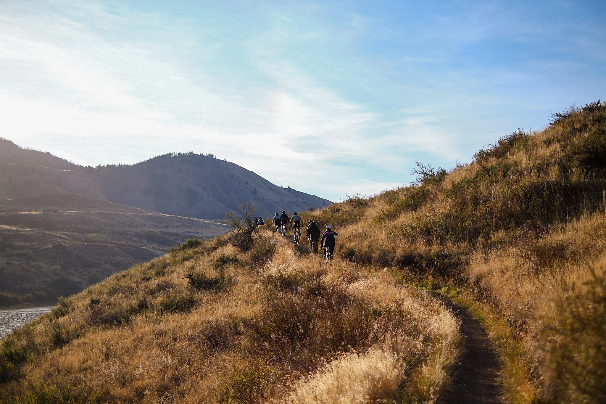
Carved over millennia by ancient glacial forces, Pipestone Canyon cleaves the Methow Wildlife Recreation Area in two beneath towering basalt cliffs topped with rugged spires. These stark rock walls give way to rolling sagebrush hills, weaving through clusters of ponderosa pine and cottonwood, broadening into expanses of open range – a striking interplay of presence, absence, light and shadow. Hawks eddy above high cliff walls, the air ripe with botanical notes of sage, yarrow and earthy bunchgrass.

Sun Mountain Trail Network
The Cowbells segment of the Canyons, Coulees & Cowbells route is just one approach (of many) to the vast Sun Mountain system, which radiates out from the Sun Mountain Lodge across a mix of private property and National Forest lands. Bring a map and expect a dynamic mix of doubletrack roadbed, meandering meadow trails and moderate frontcountry flow. The Sun Mountain complex is built and maintained via partnership between EMBA’s Methow chapter and the Sun Mountain Lodge.


Methow peoples
Native Methow (sp̓aƛ̓mul̓əxʷəxʷ) peoples, named for blunt hills around a low valley, have inhabited this particular corner of the Okanogan region, from the Methow River drainage to the Columbia River Basin, for over 500 generations – that is a timespan of over 13,000 years. This territory includes today's towns of Malott, Monse, Brewster, Pateros, Methow, Carlton, Twisp, Winthrop and Mazama.
The Methow Tribe is considered part of the Plateau Culture area, based on similarities in language and culture amongst the tribes of this region. While culturally distinct and diverse, there are a great deal of shared social practices, beliefs and teachings amongst the Colville Confederated Tribes, the ancestral territories of which extend across eastern Washington and into portions of British Columbia, Oregon and Idaho. This expanse covers approximately 39 million acres as the traditional territories of the Lakes, Colville, Okanogan, Moses-Columbia, Wenatchi, Entiat, Chelan, Methow, Nespelem, Sanpoil, Chief Joseph Band of Nez Perce and Palus Tribes.


Methow: Canyons, Coulees & Cowbells
51.3 miles | 5220 ft | 30% singletrack, 50% gravel and backcountry dirt track, 20% paved | 55c min – 2” plus recommended | Services in Winthrop and Twisp
The Canyons, Coulees & Cowbells loop is a meandering inner Valley mixed-terrain ride sandwiched between what can be thought of as two mountain bike rides, starting in the Pearrygin Lake trails and closing things out through the Sun Mountain network. Take note that Thompson Ridge adds quite a bit of punchy singletrack climbing on the back end, thus despite relatively modest numbers, this edition leans into MTB climbing ratios, so plan accordingly. If you like your gravel with expansive valley views, frontcountry foothills and love digging into trail systems on drop bar bikes, this is the one for you!
Highlights
Smooth, flowing singletrack around Pearrygin Lake State Park.
Rolling golden foothills of the Methow Winter Range & Wildlife Refuge.
Dip your toes in the healing waters of Campbell Lake and Twisp River.
Pipestone Canyon. Sublime valley trails through unique geography and stunning rock formations.
Twisp: Blue Star Coffee, Old Schoolhouse Brewing Taproom, Glover Street Market and more!
Sun Mountain Trails are some of the most dropbar-friendly singletrack lines in the region. Explore with gusto.
Patterson Lake high-line singletrack trail skirts the lake with multiple lake access points.
Winthrop community trail rambletrack back into town.


METHOW: canyons & coulees
40 miles | 3547 ft | 55% unpaved dirt track and gravel, 45% paved | 42c min – 2” plus | Services in Winthrop and Twisp
The Canyons & Coulees loop is identical to the version above for the first 75% of the ride, but this edition cuts out the backend singletrack, instead meandering the gentle gravel rollers of Elbow Coulee. This option closes out the loop with a gentle paved descent back into Winthrop.
Highlights
Smooth, flowing singletrack around Pearrygin Lake State Park.
Rolling golden foothills of the Methow Winter Range & Wildlife Refuge.
Dip your toes in the cool waters of Campbell Lake.
Pipestone Canyon. Sublime valley trails through unique geography and stunning rock formations.
Twisp: Blue Star Coffee, Old Schoolhouse Brewing Taproom, Glover Street Market and more!
Elbow Coulee’s sublime, gently-rolling gravel backroads.
METHOW TRAILS
The Methow Trails system includes over 120 miles of singletrack for Nordic skiing, mountain biking, trail running and hiking. Founded in 1977, Methow Trails is committed to the long-term economic sustainability of the community and natural resource protection throughout the Valley. Through collaborative partnerships between USFS, Fish & Wildlife and a patchwork of private landowners, Methow Trails facilitates public access to this extensive network which includes backcountry epics like Angel’s Staircase and Cutthroat Pass to the entire Sun Mountain Trails system to family-friendly community trails connecting the entire Valley.


WINTHROP
Winthrop is a curious confluence of worlds. It presents like an Old West movie set, all sunbleached boardwalks and swinging saloon doors but with a premium granola-athletic sensibility. Like a Colorado mountain town in the early 80’s, the Methow is ripe with second homes and upscale lodges tucked into the periphery but prefers to lead with uncluttered rolling hills, lazy rivers and an leisurely pace to its comings and goings.


Twisp
Twisp is the artsy, lived-in cousin to Winthrop’s touristy Wild West facade. This is where real people live, work, eat and drink with a distinctly approachable character. It is also the smallest certified creative district in Washington State. Despite its compact size, Twisp has a thriving arts scene, with galleries, studios, and public art installations. The Methow Valley Community Center and TwispWorks, a cultural hub housed in a former ranger station, provide space for artists, makers, craft brewers, food trucks and more. Highlights include Blue Star Coffee Roasters, OSB Taproom, and Glover Street Market.

Terms of Use: As with each adventure route guide published on OMTM.CC, should you choose to cycle this route, you do so at your own risk.
1. The www.omtm.cc site and @omtm.cc Instagram account (collectively, the “Site”) are owned and operated by Our Mother the Mountain LLC (“OMTM”). The Site is primarily a creative project presented by OMTM and other contributors, but it is increasingly being used as a resource for other cyclists seeking challenging and compelling cycling routes. As such, we want to be clear about what the Site is and is not.
2. It is a creative project and may be used as (a) one resource (of many) for potential routes and (b) a source of inspiration for cyclists.
3. It is not designed to be a replacement for your own diligence and judgment. You should engage in significant additional diligence, and use your judgment regarding the route and your abilities, before embarking on any route described on the Site. You are solely responsible for obeying all public and private land-use restrictions and rules, carrying proper safety and navigational equipment, and following the #leavenotrace guidelines.
4. The information on the Site is for general information purposes only. While we made reasonable efforts to ensure the information was up-to-date and correct when it was posted, the information may be incorrect, incomplete, or outdated. We make no representations or warranties about the completeness, timeliness, accuracy, reliability, or quality of the information. Nor are we able to promise anything regarding weather, route conditions, or route availability. Everything is provided on an “AS IS” and “AS AVAILABLE” basis, and any reliance you place on information available through the Site is at your own risk.
5. Without limiting the foregoing, OMTM is not responsible for GPS content provided by third-party contributors or third-party sites or platforms (such as Discord, Google Groups, and Strava Club) that may be linked or referenced on the Site: we do not own or operate such sites or platforms and are therefore unable to vouch for any content on those sites or platforms.
6. Cycling is an inherently dangerous activity, and we are unable to control the actions of third parties (including without limitation other cyclists or users of the routes). As such, the Site is not designed (or able) to reduce or eliminate your risk of injury, death, or property damage. We assume no responsibility for injury, death, or property damage.
7. You and your heirs, personal representatives, and assigns, agree to indemnify, defend, and hold OMTM, its owner(s), and all OMTM contributors harmless from and against any claims arising out of or related to your use of the Site.