

This spectacular Mt. Hood tier loop links the gateway communities of Dufur, Parkdale, Hood River, Mosier and The Dalles via wild and scenic backcountry singletrack corridors. Created for the Oregon Timber Trail by Gabriel Tiller, the 143 mile, 14,500 foot circuit roughly follows Wasco and Wishram trade routes used by two namesake native chiefs to guide John C. Fremont's 1842 expedition through the territory.

I will preface by admitting I am somewhat of a late-adopter. I concede it took me longer than most to come around the appeal of bikepacking. From a distance the whole affair seemed built on elements I went to great lengths to avoid: heavy bikes, complicated preparation, open-endedness and a resignation to riding slowly. I also had the impression that somehow a straw hat, slingshot and pair of huaraches might be involved and I've never been sure I could pull off the look.
So when Dustin Klein proposed bikepacking the Oregon Timber Trail's newest standalone loop, Stiletsi & the White Crane over three days, I was hesitant. I had never done this before. I had ridden sections of the route piecemeal, but never all together, never over multiple days. 14,500 feet sounded like a lot of climbing on a loaded bike. I had a lot to learn in a short time. As one might expect, many of my preconceptions went out the window once I actually tried it. Fully-loaded weight thankfully translated to rolling stability and a sense of groundedness. Equipment became a satisfying array of puzzle pieces to fit together. Likewise, the self-sufficient nature of backcountry camping with dependable gear lifted any sense of time pressure and daylight anxiety. Most importantly I have come to understand as with other athletic disciplines, pacing is only as fast or slow as you want to make it. The weather looked stable enough. We were two months into a historic drought. So when the forecast shifted to rain over our entire first day, I thought ‘What could go wrong?’


The dalles to upper fifteenmile
We set out on a three-day timeline, gear stowed and cinched, layered in rain shells, knee warmers and gloves, departing unceremoniously into a steady drizzle. Truth is by mid-September, it had been so dry for so long in the Pacific Northwest, the arrival of rain came as a relief. Climbing gently out of The Dalles into lower Eightmile canyon, traffic fell away almost immediately. The wet weather muted Wasco County's rolling grasslands, the rippled hills and drainages saturated with a quiet melancholy. We fell into an easy rhythm. The bike felt surprisingly nimble spinning past empty farmsteads and flaxen wheatfields, through the rural districts of Emerson and Boyd en route to Dufur, our only scheduled stop of the day. Kramer's Market, a solitary downtown storefront and welcome waypoint, offered a sit-down lunch and the company of other cyclists en route to Tygh Valley.

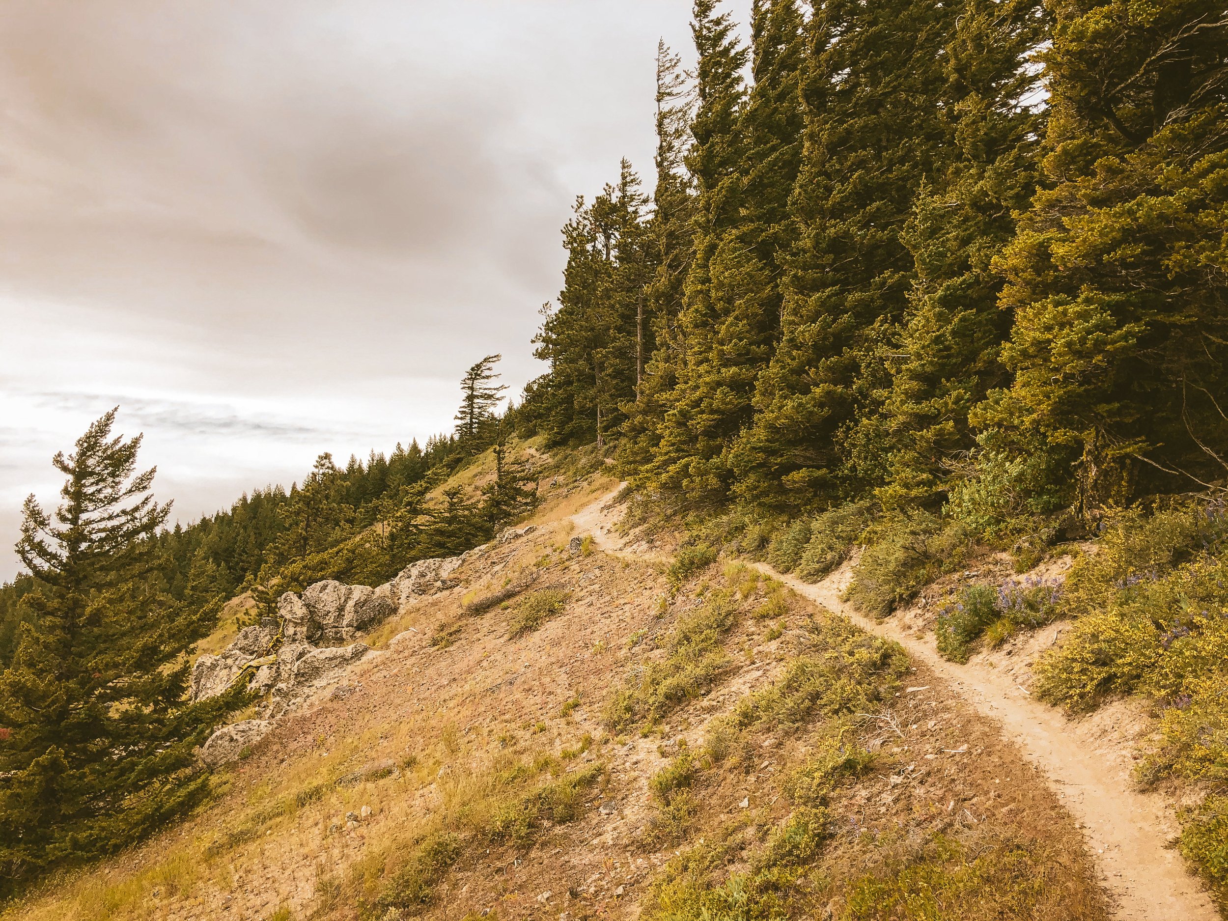
I was uneasy about the persistent rain as we rolled out of Dufur. The bulk of the day's climb still lay ahead, the weather appeared murkier where we were going, 21 miles west and 3300 feet up to Fifteenmile campground. The numbers sounded straightforward, but the reality of loaded trail climbing had reshuffled my understanding of distance and elevation. The rain thankfully began to subside by late afternoon as we eased into the sandy hillcountry. Passageways of gnarled oak and primitive Jeep trail crisscrossed stubborn watercourses, ultimately providing a segue into the sublime singletrack of lower Fifteenmile canyon. A modest climbing pace allowed us to absorb the rich detail of the scrub oak savannah, basalt ravines, narrow canyonforms and massive rock outcrops lining Springer Ridge to the south. After assessing a sheared rear derailleur battery casing, we debated camping at the Cedar Creek junction, a bit short of our target. The sheltered setting and abundant creek water were tempting but a significant stretch of difficult climbing still lay ahead. Once it was determined things were in order, we opted to keep moving.


We camped in a broad clearing amid the Fifteenmile's characteristic rocky prominences. As we fired up our stoves in the waning light, banks of eddying mist rolled up the valley from the east, encasing the ridge in a thick, swirling fog. Wet but not quite raining. The trail understory had thoroughly soaked our riding layers, socks and shoes. With temperatures dropping to the mid-40s, I was envious of Dustin's tent setup and full-coverage vestibule. My minimal setup had no rain fly and quickly became a magnet for condensation. Eventually the weather lifted overnight revealing intensely starry skies. As I lay there, cocooned in my bivy, transfixed beneath a gallery of electric stars, everything clicked.
'Okay. I get it now. This is why folks love bikepacking.'


fifteenmile to wahtum lake
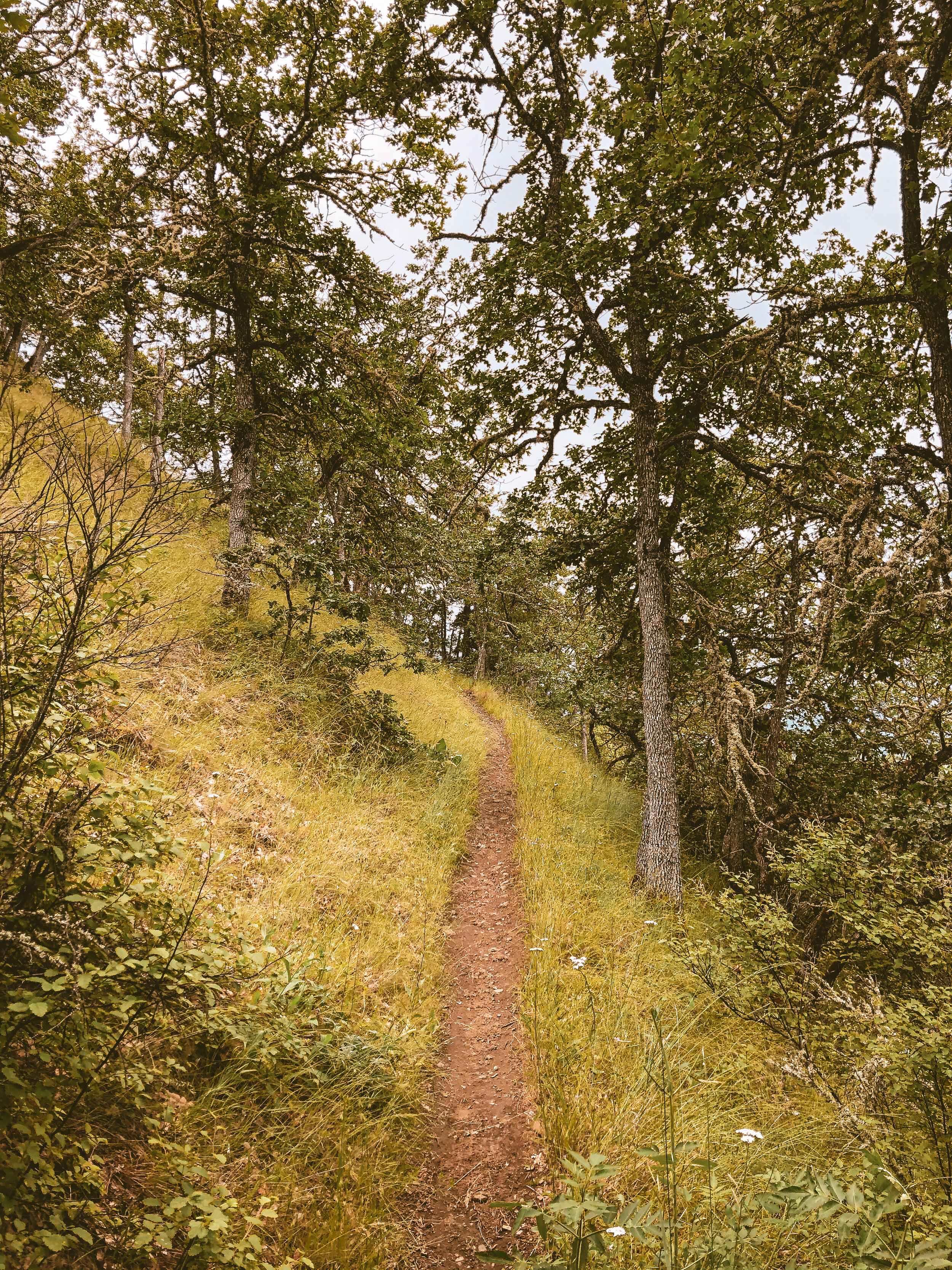
We woke to a blazing sliver of red-orange on the horizon. The air was crisp, cold and dry. My instant coffee, quite possibly the best thing I have ever tasted. Breaking down camp and loading the bikes, things seemed to fall into place as we devised better, more efficient systems for stowing our gear. The remaining stretch of Fifteenmile ascended sharply through brisk sun-dappled subalpine forest, the rain-sweetened trails very near perfection.


Surveyors Ridge unfolded as the focal point of the day, weaving northward through dense stands of fir and Mountain Hemlock. Primarily sheltered, fast and smooth, this classic line presented a satisfying progression of contrasting shapes and sightlines with a handful of exposed climbs and technical rock features. Dustin and I paused to check our brakes and lock down loose gear before dropping into the valley via Oak Ridge, which loses 2000 feet over 2 miles. Translation: steep AF! Despite my anxiety, this was precisely the scenario where I hoped the stabilizing effect of the gear-laden bikes would shine. Sure enough, my 2.25" footprint bore the burden with traction to spare down Oak Ridge's 26 hairpin switchbacks and precarious exposed shale, dropping us into the Hood River valley just east of Parkdale. We arrived at the local brew pub a bit road-ragged beneath a glaring midday sun. The abrupt scene change from pristine backcountry to crowded tourist destination was a bit jarring but the food, kombucha and downtime proved to be a solid combination.


After lunch we restocked at McIsaac's Grocery, rolling west out of town, amid bucolic fields of lavender, pinot and riesling, settling in for a long afternoon climb. The buttes and ridges on the valley's west side have a distinct utilitarian feel, underlaid with a network of irrigation ditches channeling water to the agricultural bottomlands below, the foothills patterned with patchwork logging parcels in varying stages of regrowth. We found ourselves amiably climbing quiet National Forest roads, gradients ticking up successively around each switchback. Unseen waterfalls and creeks gurgled deep in the roadside foliage as we snaked along the east side of Waucoma Ridge toward Wahtum Lake. We arrived at the campground with daylight to spare, situated our gear and hiked down to the lake for a dip. Wahtum Lake sits just inside the Mark O. Hatfield Wilderness boundary, and is one of several small high elevation lakes lining Waucoma Ridge. We noted several dispersed campsites along the lake, but between the wilderness restriction and steep, stair-lined trails, camping higher up seemed the best option. We settled in for the evening beneath a vaulted ceiling of old growth hemlock and cedar.

wahtum lake to the dalles
Dustin and I kicked off the morning with a vigor, earning our turns, so to speak, by climbing straight into the resplendent Anthill - Rainy - Wahtum trail complex. Our way forward, a 17% tightrope of piney duff strung at oblique angles, traced the spine of Waucoma Ridge northward. Sometimes overgrown and slight, other times a wideset primitive wagon road, the singletrack sequence traversed cascading scree and narrow ledges with commanding views east and west. The line from Wahtum to Rainy lake skirts the eastern boundary of the Hatfield Wilderness, a region palpably raw and abundantly wild. Pitching downward to Rainy Lake, the ridgeline plunged through jagged boulders, hanging meadows and lush primeval forest. Our momentum carried us into the otherworldly Rainy-Kingsley irrigation trail, gradually leveling into a flat, smooth and tranquil passageway, at times barely discernible through dense deciduous undergrowth.


And just like that, the trail ended. We emerged from the backcountry into a clamorous world of dusty gravel populated with pickup trucks and mountain bikes. A short climb above Kingsley reservoir marked yet another scene change as we entered Post Canyon's iconic red soil and loose powdery moondust. While the Post Canyon system presents any number of modular lines into Hood River's pastoral west side, the official route utilizes a playful combination of Dirt Surfer, Whipsnake and Borderline trails, which crisscross and roughly parallel the system's primary access roads. Being on fully-loaded rigid bikes, we settled on a hybrid approach, starting in the trails then transitioning to smooth gravel out through the bustling Seven Streams staging area. Driven by visions of tacos, we forewent the lower Indian Creek trail and beelined it to a proper lunch, after which we picked up the trail's upper stretch along the highland bluffs into downtown Hood River. The creamy tarmac of the Columbia River state trail through Mosier was a dream in contrast to the bump and jostle of the backcountry. Tires humming effortlessly beneath us and the wind at our backs, the Rowena loops unfurled in a hazy blur, drawing us back toward The Dalles. Backended with a soft landing through familiar territory, our final stretch through the eastern Gorge was as fluid as it was fulfilling, a spirited tailwind easing our efforts in closing out this rich, challenging and multifarious adventure.


the gear
The platform: Boltcutter Peacemaker set up on HiFi Session 30mm carbon 650b wheels rolling Teravail Sparwood 2.1” action-treads in the ‘light & supple’ casing. The 30mm wheel internals plump the footprint out to roughly 2.25”. Extra traction and cush with no extra weight. Win-win-win. The groupset is a hybrid of SRAM Force + Eagle XX1 modified with a Ratio Tech 11-12spd conversion kit so the Force plays w/ the Eagle while keeping it mechanical. Gearing is 38t upfront w/ 10-50 cassette. Auxiliary footwear by Birkenstock.
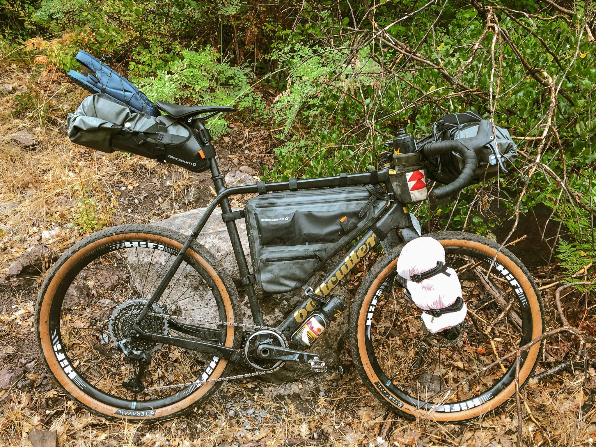
The Luggage: Blackburn across the board. Up front is their modular Outpost Elite bar bag, a two-part harness and drybag system, ideal for sleeping bag + compressable puffy layers. A set of Outpost cargo cages fork-anchored my bivy and sleeping pad down low. The frame bag is again, part of their Outpost Elite series and features well-structured waterproof compartmentalization with plenty of space down low and ultra-grippy rubberized easy access external pockets up top. The frame is on the XL end of the spectrum with an oversized downtube so did require subbing out a couple of the standard velcro attachment points for longer Voile straps. Rounding things out is the ultra-versatile Outpost Elite seat pack. Designed as a two-piece cradle and waterproof dry bag system, it is effortless to attach and remove. Both bar and seat bags feature external cargo webbing, and compression assisting air bleed valves. The full framebag forced a restructuring of bottle configuration, so I supplemented with a bar-mounted Snackhole from Makeshifter Canvas Works, which is always a solid option for easy cockpit-accessible snacks, light tools and water.

The Verdict: virtually everything went off much better than expected. The route experience was amazing thanks to Gabe. The company was of course stellar, thanks to Dustin! The bike performed flawlessly thanks to Ryan and the folks at Boltcutter. The wheels are the secret sauce that makes this build so exceedingly stable thanks to Josh & HiFi. The 38t x50t gearing was perfectly matched to the terrain thanks to SRAM. The lights, luggage and bag setup were fantastic thanks to Blackburn.
Which leaves the only things I would do differently squarely within the realm of my own personal choices. The first thing will be to upgrade to a more substantial and slightly roomier bivy or tent. I feel like the minimum requirements being a proper vestibule/rain fly shell and enough room to at least sit upright. While my existing bivy weighs in at only 735g, it is really only appropriate for fully dry summer conditions and was a bit like sleeping in a soggy coffin. A larger power bank will be key for next time as well. My GoalZero Flip 12 (70g) really only had enough juice to replenish the Wahoo once. Their slightly larger Flip 36 model (193g) would have been the sweet spot for three days. Lastly I will be securing my fork-mounted gear inside sturdy dry bags going forward. Anything down in the lower fork zone is susceptible to peripheral road spray, puddle-splash and moisture from wet trail underbrush.