


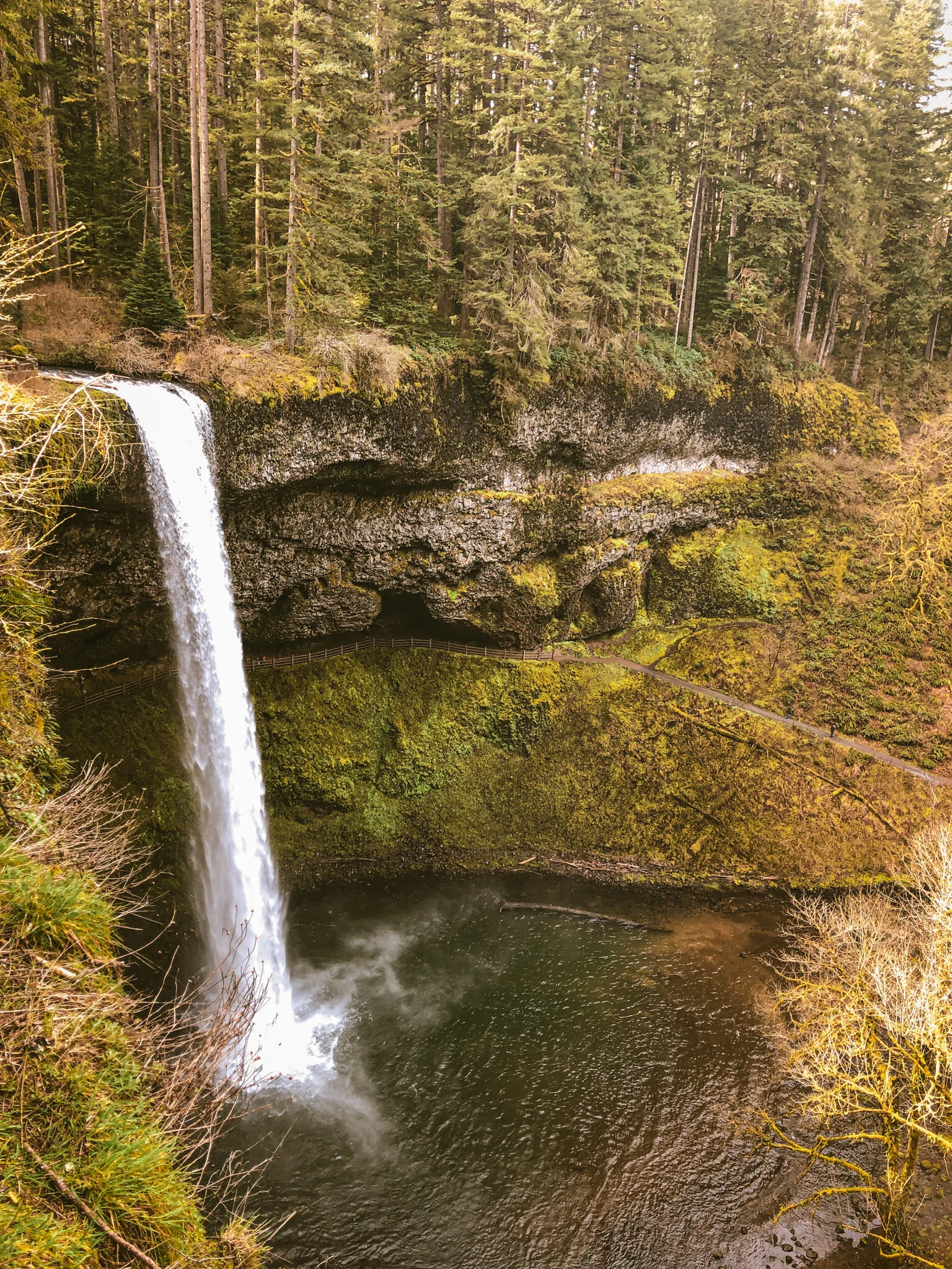
SILVER RIDGE
Silver Ridge traverses the best of Silver Falls State Park, the largest in Oregon, featuring ten iconic waterfalls and 9000 acres of densely forested trails. Here we’ve broken the route options into a full 126 mile endurance plus randonneuring adventure starting in Portland, a standard trail-intensive 48-miler and an extra light 39 mile allroad loop, each with Silver Falls State Park as the focal point.
Standard Version: this time around the standard version is the outlier in terms of terrain. The standard shares the same front + back-end as the extra light loop but with a hearty dose of deep trail-intensive adventure in the middle. In a nutshell - Silverton-based quiet country rollers climbing into a deep perimeter trail loop through Silver Falls finishing with quiet country rollers back to Silverton.
Endurance Plus 200k: is the only option starting + finishing in Portland and as such will have significant paved transport stages through the communities of Oregon City, Canby and Silverton. In a nutshell - this is a 200k randonneuring ride and a big, mostly paved day from Portland to Silver Falls and back.
Extra Light: simply the southernmost segment of the 200k loop staged out of Silverton. This version keeps to pavement and smooth gravel surfaces. In a nutshell - just a highly condensed version of the 200k loop out of Silverton, easily ridden on 35c tires.


Molalla Peoples
The Silver Falls region comprises part of the larger ancestral lands of the Molalla peoples. The name Molalla refers to like-speaking Indigenous peoples who occupied the greater part of the Cascade Range in Oregon, from Mount Hood on the north to Mount McLoughlin on the south. The name owes its historical currency to a Chinookan name of obscure origin, recorded in the forms [muˈlɑlɪʃ] and [ˈmolɑlɪʃ].
The best documented aspect of Molalla culture is the language through which it was transmitted. From the mid-nineteenth century into the twentieth, a succession of scholars transcribed samples of spoken Molalla from a people known to anthropologists as the Northern Molalla and known to themselves as the Latiwi or Lati-ayfk people. Molalla was formerly classified as part of the so-called Waiilatpuan language family, together with the Old Cayuse language (the language spoken by the Cayuse people of northeastern Oregon and southeastern Washington in the early nineteenth century). Linguists have since concluded that Molalla shares a remote common ancestry with other languages of the same region, especially with the neighboring Sahaptin, Nez Perce and Klamath languages.
Most sources agree that Molallas subsisted primarily on game, especially deer and elk, supplemented by aquatic and vegetable resources that included salmon and steelhead in mountain streams, camas and hazelnuts on prairies and savannas in the west, and prized mountain huckleberries in the high Cascades. Game provided fur, feather, and hide for clothing and regalia, as well as meat. Huckleberries were either dried whole or processed into cakelike loaves, which along with venison and dressed deer and elk hides, were important Molalla contributions to regional intertribal exchanges of foods and valuables. The Chinookan village-complex at Willamette Falls near Oregon City was one place where such exchanges customarily took place.


All three Silver Ridge variations go through the town of Silverton in some capacity. Both of the shorter loops stage out of Coolidge & McClaine Park. It is easy and convenient w/ plenty of space and available restrooms. Coffee Station in downtown Silverton serves espresso, pastries, ice cream and a dreamy array of garden starts and boutique nursery items all on a cozy patio overlooking the river. Highly recommended if you like stuff that’s good! Gallon House Brewpub/biergarden looked quite appealing post-ride, with plenty of outdoor seating, though we didn’t partake.
WARNING: We experienced a pair of aggressive dogs running out into the road, giving chase and biting at us. The property where they live is marked in all three Silver Ridge route variations. It is the ONLY house near the road along the gravel portion of Silver Ridge Road prior to the gated connector into the park. Several other riders have had this same issue. The dogs will typically come running out from the house on the right. Ride fast as you approach this property, keep a sharp eye out for the dogs and be prepared to sprint and yell ‘NOOOO’ super loud if need be. Luckily it is a gravel roller heading down, so pretty easy to get away from them if you see them coming.


EXTRA LIGHT
39.1 MILES
2667 FEET
ROUTE FORMAT: LOOP
SURFACE: 70% PAVED, 30% GRAVEL/FOREST ROAD
TIRES: MINIMUM OF 35C
SERVICES: COFFEE + FOOD IN SILVERTON
ROUTE DETAILS
STANDARD
Pay close attention to the tire recommendation here. The 10 mile singletrack loop through Silver Falls is going to require handling chops, technical riding skills and a beefier tire setup than the other two route variations. Think of it as a classic OMTM S’mores sammich: a little pavement, a little gravel with a heavy helping of singletrack in the middle. The trail portion has quite a few steep technical sections, both climbs and descents, that burn a lot of matches, so to speak, so budget accordingly.
The Catamount and Buck Mt. loop trail sections skirt the actual fireline from the devastating 2020 wildfire season. Adjacent trail sections along upper Catamount and Lost Creek trails are still closed, so please respect the closures and keep to our recommended line which only includes open trails.
48 MILES
3965 FEET
ROUTE FORMAT: LOOP
SURFACE: 60% PAVED, 20% GRAVEL, 20% singletrack
TIRES: MINIMUM OF 47C. 2.1” recommended
SERVICES: COFFEE + FOOD IN SILVERTON
ROUTE DETAILS
ENDURANCE PLUS
A couple of things to note re. the endurance plus edition. Given the distance on this one, it is mostly a paved affair w/ lots of service options along the way in Oregon City, Canby and Silverton. Probably a good idea to bring lights in case things take longer than expected. Also note that the Canby ferry at mile 23 is cash only and costs $3, so plan accordingly.
126.4 MILES
6229 FEET
ROUTE FORMAT: LOOP
SURFACE: 90% PAVED, 10% gravel/FOREST ROAD
TIRES: MINIMUM OF 35C.
SERVICES: COFFEE + FOOD IN SILVERTON
ROUTE DETAILS


Terms of Use: As with each adventure route guide published on OMTM.CC, should you choose to cycle this route, you do so at your own risk.
1. The www.omtm.cc site and @omtm.cc Instagram account (collectively, the “Site”) are owned and operated by Our Mother the Mountain LLC (“OMTM”). The Site is primarily a creative project presented by OMTM and other contributors, but it is increasingly being used as a resource for other cyclists seeking challenging and compelling cycling routes. As such, we want to be clear about what the Site is and is not.
2. It is a creative project and may be used as (a) one resource (of many) for potential routes and (b) a source of inspiration for cyclists.
3. It is not designed to be a replacement for your own diligence and judgment. You should engage in significant additional diligence, and use your judgment regarding the route and your abilities, before embarking on any route described on the Site. You are solely responsible for obeying all public and private land-use restrictions and rules, carrying proper safety and navigational equipment, and following the #leavenotrace guidelines.
4. The information on the Site is for general information purposes only. While we made reasonable efforts to ensure the information was up-to-date and correct when it was posted, the information may be incorrect, incomplete, or outdated. We make no representations or warranties about the completeness, timeliness, accuracy, reliability, or quality of the information. Nor are we able to promise anything regarding weather, route conditions, or route availability. Everything is provided on an “AS IS” and “AS AVAILABLE” basis, and any reliance you place on information available through the Site is at your own risk.
5. Without limiting the foregoing, OMTM is not responsible for GPS content provided by third-party contributors or third-party sites or platforms (such as Discord, Google Groups, and Strava Club) that may be linked or referenced on the Site: we do not own or operate such sites or platforms and are therefore unable to vouch for any content on those sites or platforms.
6. Cycling is an inherently dangerous activity, and we are unable to control the actions of third parties (including without limitation other cyclists or users of the routes). As such, the Site is not designed (or able) to reduce or eliminate your risk of injury, death, or property damage. We assume no responsibility for injury, death, or property damage.
7. You and your heirs, personal representatives, and assigns, agree to indemnify, defend, and hold OMTM, its owner(s), and all OMTM contributors harmless from and against any claims arising out of or related to your use of the Site.