

Canyon Creek unfolds like a highlights reel of summer in the Cascades – an expression of boundless evergreen punctuated by exposed ridgelines, roadside huckleberries and sunwarmed wildflower meadows. Crumbling forest roads dive deep into shady river valleys like portals to a secret world. Velvety roadbeds return to nature beneath craggy volcanic outcrops and stoic stands of old growth. This 65-mile backcountry adventure showcases the Gifford Pinchot in full regalia, the wild and wonderful Stevenson Ridge, Cougar Rock, the Tatoosh hills and all the volcanic vistas in between. But more than just an assemblage of stunning focal points, Canyon Creek feels like a seasonal meditation – an experiential love letter to the longest and deepest days of Cascadian summer.


The Gifford Pinchot National Forest contains 1.32 million acres of old and second-growth forest, 8 designated Wilderness areas, 7 river systems, 21 major lakes, 2 colossal stratovolcanoes (St. Helens and Adams), a third volcanic behemoth to the north (Rainier) and the largest roadless area in Washington, the Dark Divide. By the numbers it is almost incomprehensibly massive. So where to start?
The Wind River corridor north of Carson makes a relatively accessible point of entry. This sprawling backcountry region presents a dizzying array of possible routing combinations, National Forest arterials, secondary connectors, and rowdy Jeep trails all spinning off into the hinterlands – each one an adventure in its own right. Riding here feels a bit looser than other places. Routes are less fixed and more modular in character, allowing any number of adventures to be parsed from a broad menu of options.
But if we had to pick just one – it would be Canyon Creek.

Canyon Creek’s elevation profile consists of two major climbs with two corresponding descents. Break it into two days for an overnighter or do it as one big day. For these purposes we’ve staged out of the Panther Creek campground area, but it could just as easily start in Carson, the Wind River work center or nearby Hemlock picnic area. In this case the route is bookended by Warren Gap, a gentle warm-up and cooldown easing riders in and out of the backcountry.
The Climb
Lookout Mountain Road is an absolute diamond in the rough. We’ve championed this stunning climb for years, so were naturally delighted to see it included in the Dark Divide 300. Running through the heart of the Wind River Experimental Forest, this sublime ascent, also called NF41, is a dramatic illustration of Mother Nature's powers of regeneration. 41 has the feel of a tangly gametrail, expanding and contracting, weaving around, under and through debris and fallen trees. The gradients are exceedingly gentle, the scenery abundantly wild and its orientation along Stevenson Ridge provides fantastic access to 4220, Cougar Rock and points north. 41 climbs west out of the back of the old Wind River Arboretum facility through a fair amount of deadfall and debris, gradually narrowing to several miles of well-worn singletrack before opening into primitive forest road around the intersection with the Pacific Crest Trail.


One of the most stunning stretches of road in the Wind River area, 4220 is a compact serving of high country magic, meandering ridgetops, volcanic outcroppings, rocky basins and several of the region’s most photogenic lines. 4220 approaches the iconic Cougar Rock from the south making it a hub from which some of best backcountry arterials radiate. Our loop picks up 42 at Cougar Rock and continues climbing through the Tatoosh Hills area, dipping in and out of dense forest, huckleberry thickets and open, exposed ridges. In the early season, a handful of hillside creeks trickle through the moss and rock – a good opportunity to for water refill.

Descent no. 1
Things trend downward around mile 20. It is fast, loose and full of rocks and ruts, so keep on your toes. Thus begins a continuous 15-mile drop deep into the Canyon Creek drainage. Expect a patchwork of densely forested, moderately overgrown doubletrack and curiously smooth backcountry pavement, crumbling in places, slowly overtaken by mosses and shrubs. Lower 53 has quite a few sunken grades, cracks and sinkholes – so again – stay sharp on this descent as the surface deteriorates considerably the lower you get.


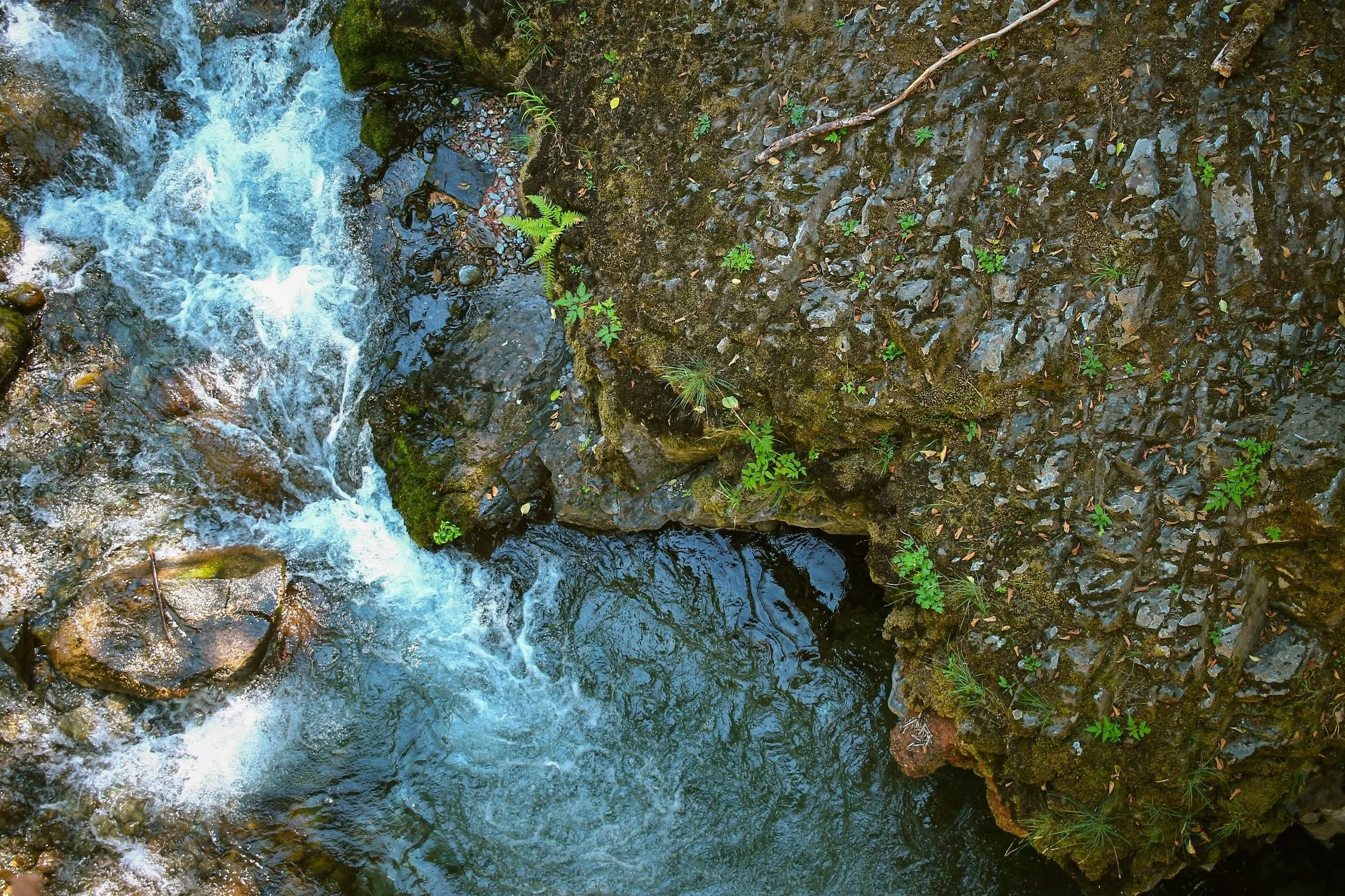


canyon creek
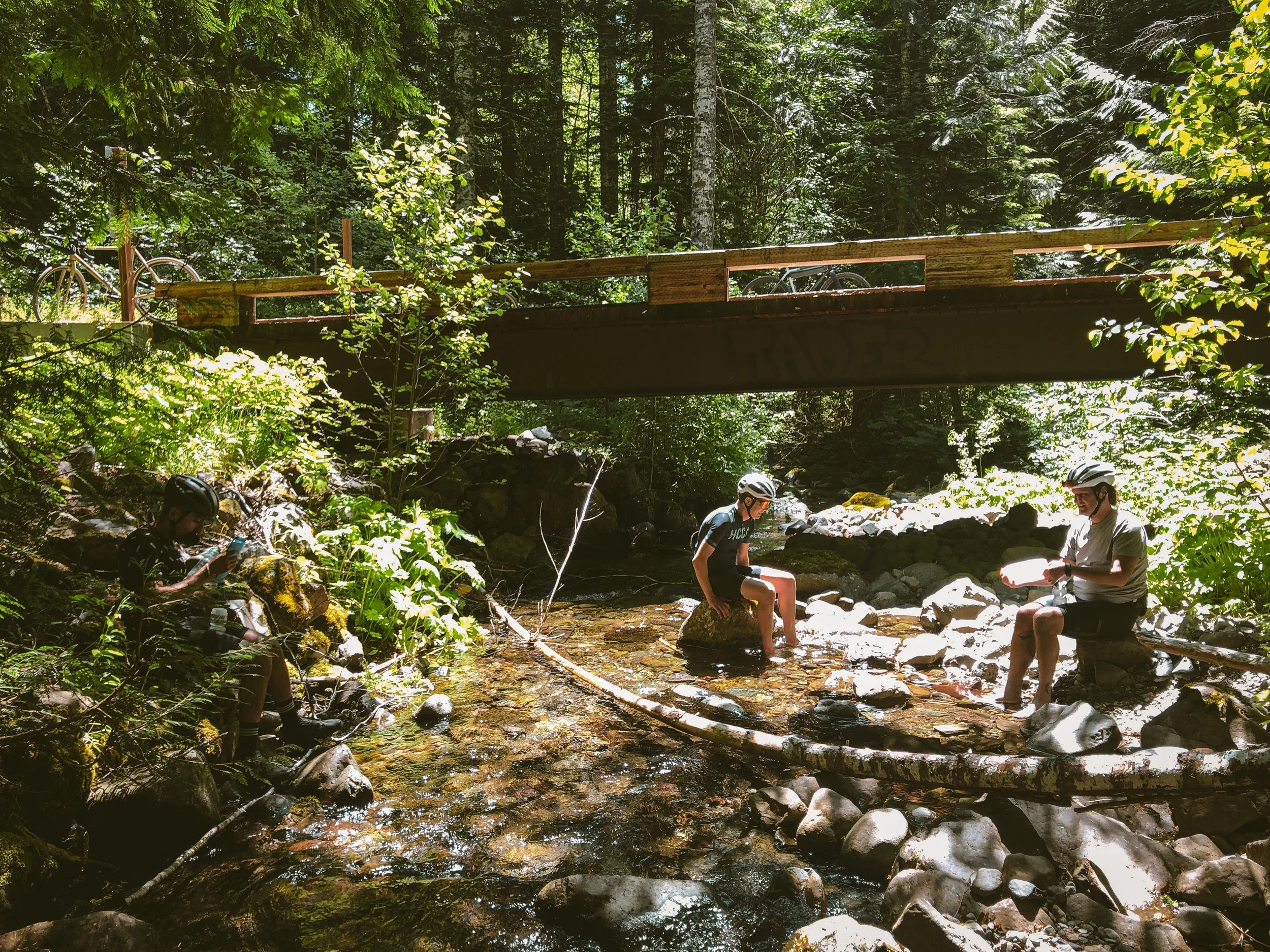
The valley floor is lush, cool and shady. Canyon Creek feels incredibly deep and remote, and rightly so considering our journey up to this point. Though it seems odd, you’re likely to encounter cars and people near the Canyon Creek campground area, which is accessible from the west via 54. Be sure to take advantage of the slight out-and-back spur down to the bridge to 54. There you will find a stellar lunch spot with ample water refill and the opportunity for a dip. Those on the bikepacking program will find the campground is tent-only, lightly-used and tucked into dense, shady forest along the creek – though you may be sharing space with car-campers or small RV’s. There is also plenty of dispersed opportunity further up NF37, which breaks out into incredible valley views across to the Soda Peaks.


The Climb back Out
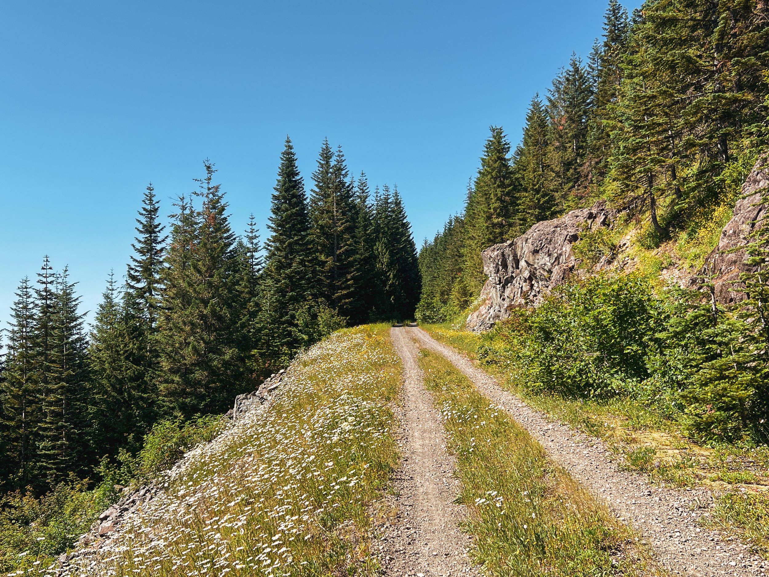
The climb out along 37 is one of the highlights of the day, gaining 2900 feet over 12 miles. This primitive stretch of rugged doubletrack is impassible to cars. Washouts and substantial overgrowth filter out any motorized traffic, rendering the experience fantastically wild – and ideal for backcountry riding. Dense clusters of red alder, vine maple and salal crowd the roadway, forming narrow, sundappled tunnels of green. Rocky grades twist and turn along the valley upward though open sections of volcanic scree. Riders may come across black bears or cougars through this stretch. Be mindful that this is a very active wildlife corridor – make lots of noise, announce yourself, and consider a set of bear bells to avoid any unexpected encounters. If you listen carefully along the climb, you will hear a series gurgling creeks and small waterfalls through the brush off to the right. If one should need to filter, one will find options.


The descent of dreams
And just like that, 37 crests into the inimitable NF54, yet another highlight of the loop. The east end of 54 is quite possibly the best paved descent in this neck of the Gifford, dropping 2700 feet like a ten mile roller-coaster of buttery, perfectly banked backcountry tarmac. 54 eventually deposits riders into the Little Soda Springs/Szydlo/Hemlock nexus with easy access to known quantities like the Wind River Highway, Carson-Guler Road, Warren Gap, Panther Creek and points south such as Carson, Stevenson and Bridge of the Gods.


canyon creek: nf41 edition
65.2 MILES
8134 FEET
ROUTE FORMAT: LOOP
DISCIPLINE: 1-DAY GRAVEL OR 2-DAY BIKEPACKING
SURFACE: 70% UNPAVED, 30% PAVED
TIRES: MINIMUM OF 45C. 2” optimal. TUBELESS HIGHLY RECOMMENDED
BIKE: GRAVEL/ADVENTURE/HARDTAIL
WATER FILTER: REQUIRED
SERVICES: NO
FULL RIDE WITH GPS ROUTE
canyon creek: nf42 edition
This option utilizes 42 to access Cougar Rock rather than 41. By the numbers, it may not look all that different, but 42 is a far gentler climb with a smoother runway into the highcountry. Because this version double-dips on both Szydlo Road and lower 54, you’ll get twice as much pavement for a smoother, more easygoing experience overall. Think of this edition as Canyon Creek lite.


With a max gradient of 9.3, the climb to or descent from Cougar Rock via 42 is one of the mellower ways up or down. Shady forested foothills offer plenty of available creekwater options for filtering down low. 42 winds through dense evergreen and tunnels of brushy salal, opening into dramatic rock outcroppings up high with stunning valley views.
62.5 MILES
7480 FEET
ROUTE FORMAT: LOOP
DISCIPLINE: 1-DAY GRAVEL OR 2-DAY BIKEPACKING
SURFACE: 60% UNPAVED, 40% PAVED
TIRES: MINIMUM OF 45C. 2” optimal. TUBELESS HIGHLY RECOMMENDED
BIKE: GRAVEL/ADVENTURE/HARDTAIL
WATER FILTER: REQUIRED
SERVICES: NO
FULL RIDE WITH GPS ROUTE
Terms of Use: As with each adventure route guide published on OMTM.CC, should you choose to cycle this route, you do so at your own risk.
1. The www.omtm.cc site and @omtm.cc Instagram account (collectively, the “Site”) are owned and operated by Our Mother the Mountain LLC (“OMTM”). The Site is primarily a creative project presented by OMTM and other contributors, but it is increasingly being used as a resource for other cyclists seeking challenging and compelling cycling routes. As such, we want to be clear about what the Site is and is not.
2. It is a creative project and may be used as (a) one resource (of many) for potential routes and (b) a source of inspiration for cyclists.
3. It is not designed to be a replacement for your own diligence and judgment. You should engage in significant additional diligence, and use your judgment regarding the route and your abilities, before embarking on any route described on the Site. You are solely responsible for obeying all public and private land-use restrictions and rules, carrying proper safety and navigational equipment, and following the #leavenotrace guidelines.
4. The information on the Site is for general information purposes only. While we made reasonable efforts to ensure the information was up-to-date and correct when it was posted, the information may be incorrect, incomplete, or outdated. We make no representations or warranties about the completeness, timeliness, accuracy, reliability, or quality of the information. Nor are we able to promise anything regarding weather, route conditions, or route availability. Everything is provided on an “AS IS” and “AS AVAILABLE” basis, and any reliance you place on information available through the Site is at your own risk.
5. Without limiting the foregoing, OMTM is not responsible for GPS content provided by third-party contributors or third-party sites or platforms (such as Discord, Google Groups, and Strava Club) that may be linked or referenced on the Site: we do not own or operate such sites or platforms and are therefore unable to vouch for any content on those sites or platforms.
6. Cycling is an inherently dangerous activity, and we are unable to control the actions of third parties (including without limitation other cyclists or users of the routes). As such, the Site is not designed (or able) to reduce or eliminate your risk of injury, death, or property damage. We assume no responsibility for injury, death, or property damage.
7. You and your heirs, personal representatives, and assigns, agree to indemnify, defend, and hold OMTM, its owner(s), and all OMTM contributors harmless from and against any claims arising out of or related to your use of the Site.