

equal parts golden lava plateau and swale canyon, this enchanted watershed managed to land a wild and scenic river designation, though technically only a creek. with headwaters high in the evergreen fringe of the cascade rain shadow, fifteenmile creek drains 373 square miles of semi-arid columbia plateau, winding beneath stoic andesite terraforms into the hill country of central oregon’s rolling grasslands.

But first the backstory.
The year is 2014. GPS is a frivolous luxury. Gravel simply occupies space between cross races. Navigation means cryptically-scrawled cues taped to stems and bars. 33c is the largest tire available, supple as a frosty garden hose, invariably set up with patchy secondhand tubes. What a time to be alive! It was my first running of the Oregon Stampede. A few Pro-Bars and two small bottles were plenty fine because, convenience stores right? It was only 127 miles and 9454 feet. Psssh, I did the STP and that’s like, way longer. I didn’t need to look up ‘the route’ because we would just ‘follow the group’. As you can imagine, our wayfinding fell apart pretty quickly. Four hours spent wandering the White River Wildlife Area in a fever dream, chasing dead ends, finding/losing gametrails, portaging impossible hillsides in road shoes, running out of water, food and daylight. Somehow we crawled to Dufur in the dark like lone survivor Sally Hardesty, in the final scene of Texas Chainsaw Massacre, running down the tarmac, beaten and bloodied but alive.
These things leave a mark. Never again would I venture deep into the bush without ‘the route’. Never again would I underestimate this grade of terrain. That said, it was also a turning point. The hook was set. For a good long time I would be obsessively captivated by this area and its manifold mysteries. In the half-dozen or so times I’ve returned, the zone hasn’t gotten any less wild, remote or primitive, it’s just that now I understand where the roads go.
Sort of.


The Descent
Fifteenmile #456 is undoubtedly one of the best and quietest corners of the 44 trail system. It is rocky, rooty and dank up top, quintessential XC terrain, occasionally breaking out into scenic boulder-strewn vistas. dropping through dense foliage and grassy meadows to crisscross Fifteenmile Creek over a series of sagging wooden bridges. Gradually the forest begins to open into dry grassy savannah, hillsides rich with garry oak and ponderosa pine. The trail portion terminates into a tangled web of primitive roadbed locals refer to as ‘the Arizona Road’ also the confluence of Upper Fifteenmile and North-South Roads.
Confusing right? You should try it without a GPS in the dark.
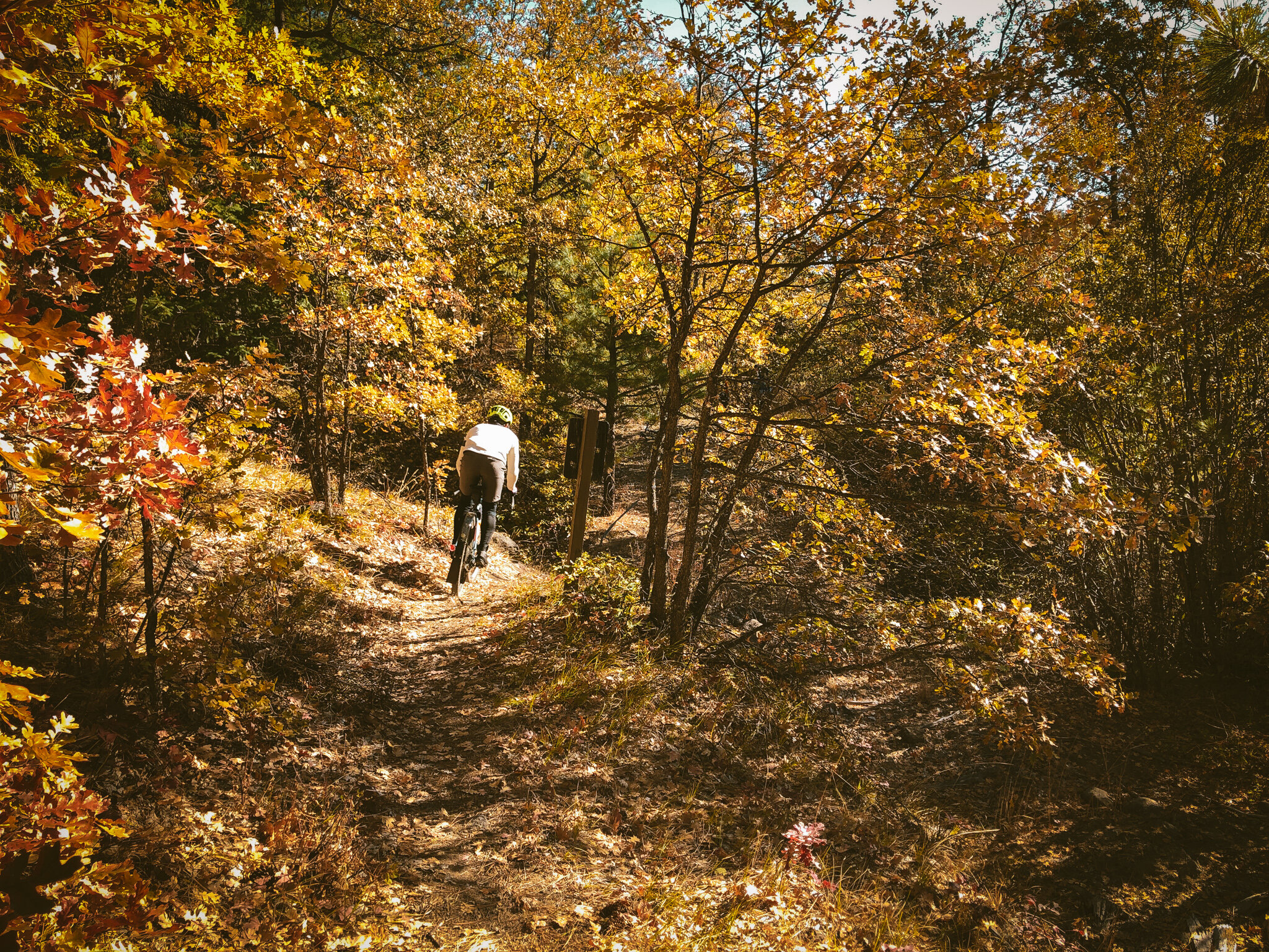

Deferring to the pepper scale, say Fifteenmile #456 is an Anaheim or a Poblano, that would make the eastbound continuity of Upper Fifteenmile Road a goddamn Scotch Bonnet; abundantly diverse, brilliantly colorful and spicy AF. The road rambles the course of Fifteenmile Creek, appearing to be many things at once. Sometimes it is a cowpath covered in ultra-fine moondust, sometimes an oak-lined carpet ride, other times a field of prickly volcanic rubble which quickly becomes a creekbed. Sometimes dry, more often wet. There are a handful of water crossings where the creek simply interweaves with the roadbed itself. Such is the nature of things around here. Full disclosure - you may have to get your feet wet.


THE VALLEY
And just like that the madness gives way to smooth two-lane blacktop through a lush agricultural valley. The remaining paved stretch into Dufur is about eight miles and clicks by effortlessly in contrast to the first twelve. In Downtown Dufur Kramer’s Market is the only game in town and will have a well-rounded selection of snacks, bevvies, coffee, beer and lunch options. Remember to drink heartily and refill all of your bottles here. There is little to no available water on the back half of the route in the clockwise orientation.
* Pro-Tip: Kramer’s also has a soda fountain with an ice machine. In the summertime, beat the exposure and heat by using an ‘ice sock’. Introduced to me by @Jbucky1 on the hottest ride I’ve ever done, I have found it to be a gamechanger for deep summer riding. Bring a single spare sock or thin stocking, fill with a moderate amount of cubed ice, tie off and hang against your upper back beneath the jersey. It will slowly melt out over the course of a couple hours, significantly lowering your body temperature in the hot sun. Give it a try, it is surprisingly effective.


Moving on, there are a handful of options for the approach into Friend. The most concise will be to lift the classic Stampede line out of Dufur via Rail Hollow. Another option is Dufur Gap to Kingsley. This will be more of a paved thing, climbing Highway 197 for a hot, windy minute. Think Cycle Oregon, Hood views, rolling bluster, golden wheat…that sort of thing. For a bigger day, extend eastward by adding in Long Hollow and Tygh Ridge. No shortage of configurable options out here but do keep in mind that Tygh Ridge will add about 2500 feet of climbing to your day.
Friend is less a town and more just a name on a map at a crossroads, an old one-room schoolhouse and a pair of old-west privies, not much of a destination to speak of. Friend is also noteworthy for being the jump-off to the aforementioned White River Wildlife Area, 30,760 protected acres stretching southeast to Tygh Valley. Abundant species include Rocky Mountain elk, bears, coyotes, bobcats and wild turkeys.


So here’s the thing about a V-shaped route. All the fun is up front, with all the work on the back end. The first half drops a rider into Dufur with roughly 500 feet gained, which obviously leaves a surplus of chuffin’ for the last 20 miles. My advice: go easy up front and save the legs for the climb.
THE climb
The valley is nice in small doses, but can be too much of the same thing for too long, so luckily phase three of our journey is imminent. Like clockwork, the tone shifts once back inside the National Forest boundary. Like so many roads in this area, our course has three different names depending on who you talk to. Camp Friend Road is also NF4421 is also North-South Road, the latter being the most commonly used. From our point of entry North-South gets awesome fast. It is a rambling primitive hillcountry connector that bumps and jostles in all the right places, wheeling ever upward to Springer Ridge. Along the way, a proliferation of questionable offshoots lie in wait. Stay vigilant, the way forward may not always be the most obvious line.


The arc of Springer Ridge veers west, splitting the distance between utility blacktop (Cold Springs Road) and our initial descent along Fifteenmile. We are now climbing one ridgeline south from our starting point and thankfully it is nowhere near as steep. As longform climbs go this one is rather approachable. The sandy rambletrack clambers upward through dense fir-tunnels and grassy clearings with ample dispersed camping appeal. Springer Ridge eventually reconnects to upper Cold Springs Road just two miles shy of the finish. There is something enchanting about this particular neck of the woods, where passing through feels a bit like stumbling into a secret; a sublime network of backcountry byways known to few and ridden by even fewer.


FIFTEENMILE hillcountry VARIATIONS
As mentioned above, we’ve presented three examples but there are of course, many more ways to configure this zone depending on personal preference. If you’re looking to get deeper into the White River area, which I’d highly recommend, dip south at the Friend schoolhouse and make a loop using Clark Mill, Tygh Creek, McCorkle, Badger Creek and North-South. For a truly epic summertime loop, extend eastward to the Deschutes and drop into Freebridge Road. MTB-centric variations are also plentiful. You may choose to start more centrally within the 44 Trails and include Lookout Mountain, Eightmile, Upper Fifteenmile or Cedar Creek trails. Like I say, there is certainly no shortage of options out here. Additionally, any of these could also be staged out of Dufur for a more traditional A-shaped elevation profile.
Because of elevation, this area is best approached late spring through fall. Keep in mind that Fifteenmile Campground sits at about 4600 feet so tends to have snow from mid-November to April or May. Another consideration will be the watery nature of watersheds…y’know creeks and whatnot, early spring is going to be very wet through Upper Fifteenmile Road. To my mind, personally, It’s part of the adventure. But I also like taking off my shoes and fording creeks now and again. We’re not saying not to try it, but it may be a bit much for some. Not to fear, we have a contingency plan.

There are two relatively straightforward workarounds…A. Upper North-South/Logging Gulch/’Arizona Road’ to Ridgetop Road on the north or B. North-South Road to Shell Rock to Springer Mill to Rail Hollow to Taylor Grade on the south side. They both sidestep the tricky sections of Upper Fifteenmile to reconvene where the pavement begins along S. Valley Road.
*The 44 Trails are built, managed + maintained by the 44 Trails Association. They put in a generous amount of work each season to keep these regional treasures open and running. Please consider donating and volunteering for trailwork events if the system is in your frequent-ride lineup.
RAIL HOLLOW EDITION
50.4 MILES
4367 FEET
ROUTE FORMAT: LOOP
SURFACE: 60% GRAVEL/DIRT, 20% SINGLETRACK, 20% PAVED
TIRES: MINIMUM OF 40C. TUBELESS HIGHLY RECOMMENDED
BIKE: ADVENTURE/GRAVEL/MTB
FULL RIDE WITH GPS ROUTE + TCS FILE
DUFUR GAP EDITION
49.4 MILES
4278 FEET
ROUTE FORMAT: LOOP
SURFACE: 60% GRAVEL/DIRT, 20% SINGLETRACK, 20% PAVED
TIRES: MINIMUM OF 40C. TUBELESS HIGHLY RECOMMENDED
BIKE: ADVENTURE/GRAVEL/MTB
FULL RIDE WITH GPS ROUTE + TCS FILE
TYGH RIDGE EDITION
63.7 MILES
5797 FEET
ROUTE FORMAT: LOOP
SURFACE: 60% GRAVEL/DIRT, 20% SINGLETRACK, 20% PAVED
TIRES: MINIMUM OF 40C. TUBELESS HIGHLY RECOMMENDED
BIKE: ADVENTURE/GRAVEL/MTB
FULL RIDE WITH GPS ROUTE + TCS FILE


Terms of Use: As with each adventure route guide published on OMTM.CC, should you choose to cycle this route, you do so at your own risk.
1. The www.omtm.cc site and @omtm.cc Instagram account (collectively, the “Site”) are owned and operated by Our Mother the Mountain LLC (“OMTM”). The Site is primarily a creative project presented by OMTM and other contributors, but it is increasingly being used as a resource for other cyclists seeking challenging and compelling cycling routes. As such, we want to be clear about what the Site is and is not.
2. It is a creative project and may be used as (a) one resource (of many) for potential routes and (b) a source of inspiration for cyclists.
3. It is not designed to be a replacement for your own diligence and judgment. You should engage in significant additional diligence, and use your judgment regarding the route and your abilities, before embarking on any route described on the Site. You are solely responsible for obeying all public and private land-use restrictions and rules, carrying proper safety and navigational equipment, and following the #leavenotrace guidelines.
4. The information on the Site is for general information purposes only. While we made reasonable efforts to ensure the information was up-to-date and correct when it was posted, the information may be incorrect, incomplete, or outdated. We make no representations or warranties about the completeness, timeliness, accuracy, reliability, or quality of the information. Nor are we able to promise anything regarding weather, route conditions, or route availability. Everything is provided on an “AS IS” and “AS AVAILABLE” basis, and any reliance you place on information available through the Site is at your own risk.
5. Without limiting the foregoing, OMTM is not responsible for GPS content provided by third-party contributors or third-party sites or platforms (such as Discord, Google Groups, and Strava Club) that may be linked or referenced on the Site: we do not own or operate such sites or platforms and are therefore unable to vouch for any content on those sites or platforms.
6. Cycling is an inherently dangerous activity, and we are unable to control the actions of third parties (including without limitation other cyclists or users of the routes). As such, the Site is not designed (or able) to reduce or eliminate your risk of injury, death, or property damage. We assume no responsibility for injury, death, or property damage.
7. You and your heirs, personal representatives, and assigns, agree to indemnify, defend, and hold OMTM, its owner(s), and all OMTM contributors harmless from and against any claims arising out of or related to your use of the Site.