

"Do you have this route on your GPS?"
"Yes."
"You should definitely delete it before every bikepacker in portland starts coming up here to glamor-gram their morning coffee."
WITH A PALETTE THIS BROAD AND A RANGE OF LANDSCAPES this fucking sublime, IT'S EASY TO FEEL COMPELLED TO KEEP THIS ONE UNDER YOUR HAT.


My suspicion however, is that climbing 3800 feet in the first 21 miles will have its own way of keeping traffic down. Make no mistake, this is a difficult route. It's got treacherous climbs up front, some eyeball-rattling rocky descents and a few moderately challenging sections that will put your handling chops to the test. It does get better, I promise, as the payoffs are many and the rewards are easily worth every cursed 12% grade pedalstroke. The sheer scope of epic moments condensed into these 50 miles gives the 'Dirty Ketchum' the rare distinction of having set a new bar for the term 'all killer, no filler'.
Giving credit where credit is due, this route is threefold in inspiration, touching segments of the annual Dirty Sellwood, Gorge Roubaix and Velodirt's 'Old Dalles' routes in a reconfigured hybrid loop which runs counterclockwise, south from Hood River along Neal Creek to connect NF-1710/1711 to Ketchum Road, eventually dropping back down into Mosier via Osborne Cutoff and Dry Creek Roads.
While you're welcome to start from anywhere in Hood River, do note that downtown tends to be fairly congested. The Twin Tunnels State Trail parking area makes a solid staging area w/ available restrooms, plenty of space and a flat, mellow rollout to the Highline climb. It does come with a $5 State Park fee.
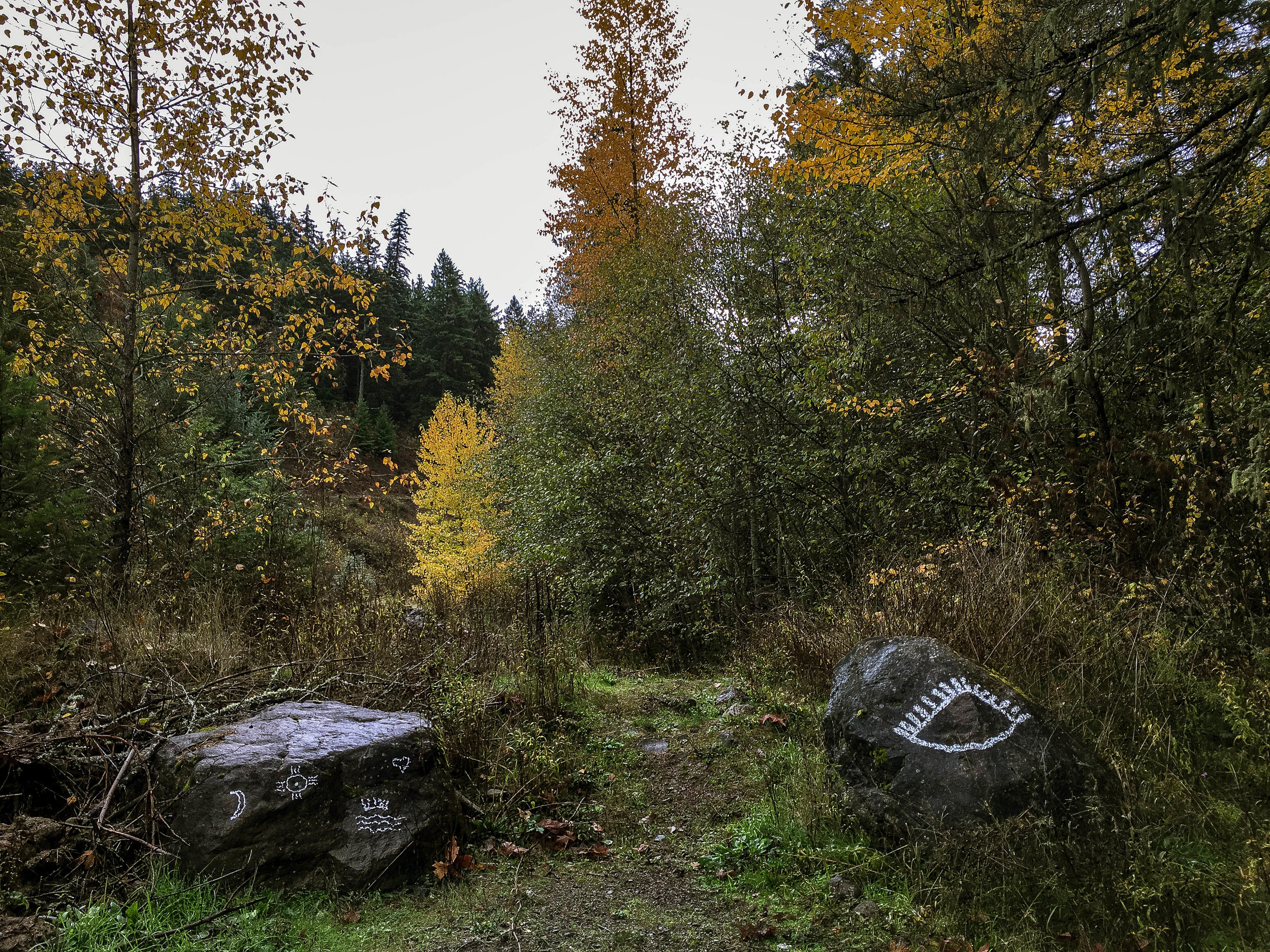
Depending on your starting point, the route begins in earnest with the Highline Road climb, merging into the pastoral rollers of Eastside Road and up into the lower Fruit Loop. Head south for 4 miles before jogging right, then immediately left onto Thomsen. This scenic rollout leads south through the eastern edge of the 'Fruit Loop', so named for the numerous apple + pear orchards and farmstead cider stands throughout the area. Thomsen T-stops into Neal Creek Road, leading us left and south once again, up into Neal Creek Canyon. The tarmac of Neal Creek ends at around mile 9.5, dead-ending in a pair of cryptically-ornamented rocks and the start of NF-1710. This is where the fun begins. 1710 angles up to left over a daunting surface of chunky rock, climbing steeply among quarries, ravines and sharp evergreen contours lining Neal Creek.


After several miles of steep, rocky climbing, 1710 mercifully begins to switchback, easing the grade if only slightly, ultimately breaking out into a clearcut vista looking down on Surveyor's Ridge Road to the west. Follow 1710 around to the right, beneath the powerlines, reentering the forest on the other side, where we pick up NF-1711. Continue climbing on 1711 until mile 21.4 where you can take a moment to pat yourself on the back for having just sweated out 3819 feet in the first 21 miles.
It's all downhill from here. Sort of.


At mile 22.4, 1711 forks, presenting the option of Mill Creek Ridge to the right and 1711/John's Mill Road to the left behind the Forest Service gate. Crossing the gate to the left onto John's Mill Road, things start to get a little rough.
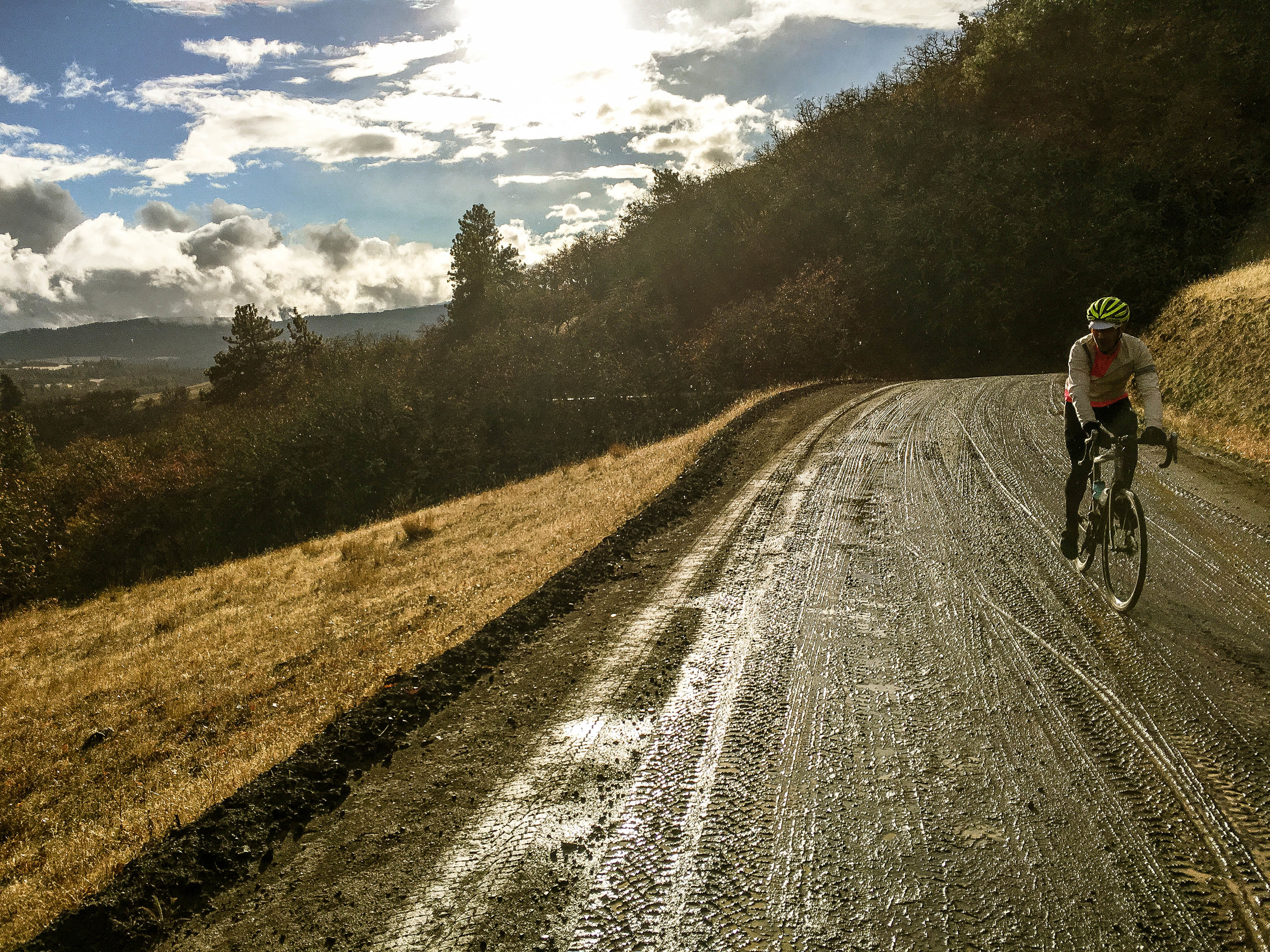
Scorched by the Rowena wildfire in 2014, the blackened and peeling spires create an otherworldly backdrop to this rough and chunky 3 mile descent. The charred trunks are spaced with an eerie symmetry and it feels like at any point, one of them could snap and come crashing down. Upon arrival at the second gate, the road thankfully transitions back to the less severe dirt of Ketchum Road. 'Smooth' only by contrast to the previous 3 miles, upper Ketchum is still rather rocky and rutted, gradually smoothing as it descends.
Ketchum Road begins rolling into a blissful 20 mile descent gradually transitioning from pine forests into the dry grassy ridges and ravines above Mosier and Rowena. Ketchum descends with a quickening pace down the ridgespines and rolling hills above Mill Creek through stands of craggy, gnarled Oregon White Oak.

The final mile of Ketchum Road winds through a series of ridiculously bucolic curves before crossing a cattle guard into Chenoweth and Vensel Roads. While Chenoweth leads directly back to The Dalles, for our purposes, bear left onto Vensel and savor the primo 9 mile descent into Mosier via the most buttery-smooth gravel in the area: Vensel, Osborne Cutoff and Dry Creek Roads. It's a left, right then another left respectively. All three roads are prominently marked. This descent sequence is about as sexy as gravel riding gets in this area! If weather permits, the Mosier swimming hole offers a solid opportunity for a dip.
Once back on Tarmac, bear left onto State Street into Mosier and take Rock Creek Road down to the right beneath 30 and start climbing, bearing right onto the Historic Columbia River Hwy Trail which is pedestrian/bike-only for 4.5 miles, passing through through the twin tunnels. Be sure to savor the spectacular Columbia River Gorge views along this stretch. Restrooms and water refill are available at the gated west end of the HCRH Trail. Continue on the Historic Highway, retracing the S-curves west back into Hood River. Of the myriad options for food and drink upon your return to Hood River, we keep coming back for the Modelo and margaritas at Hood River Taqueria.


* One thing to note is that this is a remote national forest route with no services of any kind until you arrive in Mosier where there is only a convenience store. You will need to plan accordingly for water and nutrition. Two large water bottles are highly recommended.
50 MILES
5209 FEET
ROUTE FORMAT: LOOP
SURFACE: 60% GRAVEL/DIRT, 10% chunky quarry-rock, 30% tarmac
TIRES: 33C-40c/29er-29+ heavy duty box or file tread recommended
BIKE: CYCLOCROSS/GRAVEL/mtb
WATER/SERVICES: NO SERVICES.
FULL RIDE WITH GPS ROUTE + GPX FILE
Terms of Use: As with each adventure route guide published on OMTM.CC, should you choose to cycle this route, do so at your own risk. Prior to setting out check current local weather, conditions, and land/road closures. While riding, obey all public and private land use restrictions and rules, carry proper safety and navigational equipment, and of course, follow the #leavenotrace guidelines. The information found herein is simply a planning resource to be used as a point of inspiration in conjunction with your own due-diligence. In spite of the fact that this route, associated GPS track (GPX and maps), and all route guidelines were prepared under diligent research by the specified contributor and/or contributors, the accuracy of such and judgement of the author is not guaranteed. OMTM.CC, its partners, associates, and contributors are in no way liable for personal injury, damage to personal property, or any other such situation that might happen to individual riders cycling or following this route.