

Lawetlat'la, Loowit or Louwala-Clough, the sacred smoking mountain of Cowlitz, Klickitat and Yakama legend, erupted March 20th 1980, triggering the largest known debris avalanche in recorded history. Yet within the context of Indigenous memory, this was a blip - a recent cataclysm in a much larger chain of ancestral eruptive periods.

Loowit launched its eruptive career in the Pleistocene epoch, about 37000 years ago, during the most recent of Earth’s glaciated ice ages in what is known as the Ape Canyon Stage of ancestral activity. This would be the first of many eruptive cycles to spew plumes of andesite, dacite, hot pumice and ash throughout the region. Catastrophic mudflows would follow, scouring the surrounding landscape, creating massive, deeply furrowed runoff channels. These colossally destructive forces known as lahars would shape the mountain’s uniquely singular geological and aesthetic character for millenia.
Consecrated as the stuff of legend, the Ape Canyon to Windy Ridge route exists on a short list of regional rites of passage. Renowned for its monolithic scale, commanding beauty and primordial terrain, Loowit’s challenging-yet-accessible southeast side is considered a classic for a reason. That said it is also curiously short. Just 19 miles out and back. Ape Canyon up, Plains of Abraham over, down Windy Ridge then back out the way you came.
But what if there was a better way?
Here we present the option to push a little deeper, traversing the wild and wonderful Smith Creek watershed on the back end to create a slightly larger loop. We certainly didn’t invent this configuration, but are here to sing its praises nonetheless. On paper the numbers, now 23 miles and 3900 feet of elevation, have not shifted dramatically over the out-and-back, but the experience delivers a richer, more remote backcountry feel across a much wider range of terrain - broad spectrum cyclering to be sure.
Oh, and don’t forget to bring your mountain bike.


The Climb + the plains
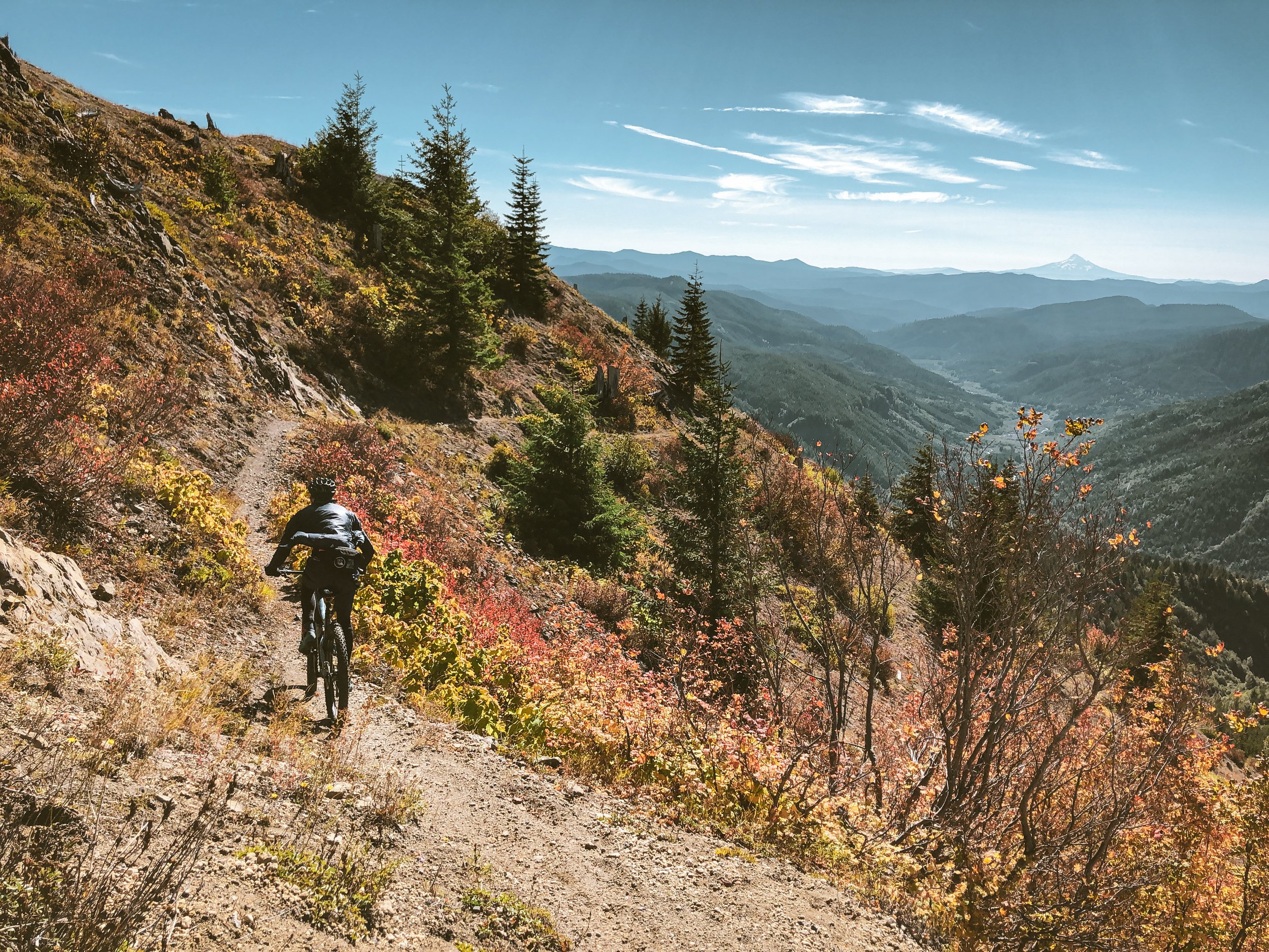
I like to think of the lower Ape Canyon Trail as a prelude to greatness; a subtle leadup to one of the more powerful reveals in the Northwest. Ascending the eastern rim of the massive Muddy River lahar flow, the narrow ridgeline meanders upward through smooth, densely forested switchbacks, a wavy band of pine-needled duff intercut with timeworn roots. Then suddenly everything changes. The trail emerges from the treeline into a yawning expanse of debris-scoured rock. Chaotic canyons twist down the mountain, powerful remnants of violent geological transformation. The scale is hard to comprehend. Riders virtually disappear into the immensity of the pumice plain, dwarfed beneath Loowit’s glaciated rim.
Entering the Plains of Abraham, the trails delineate the barren expanse between the Pumice Butte and the Dog’s Head, traversing rocky washes, gullies and precipitous drops overlooking the massive lava canyons to the east. Beyond the Nelson glacier drainage, a lithic runoff channel beneath Windy Pass, the Abraham Trail navigates a serpentine array of hummocks, or large-scale topographical mounds created by the enormous debris avalanche and subsequent landslides. These rippled hummocks rise and fall playfully, carpeted with stunted foliage and the sunbleached husks of trees leveled in the 1980 blast, eventually snaking down a steep series of sandy rollers as Tahoma (Mt. Rainier) looms on the horizon.


This iconic trail descent is a bit like navigating the spine of a brontosaurus into the blast zone. The Abraham Trail drops riders into a wideset gravel roadbed, two miles above Windy Ridge, whose paved viewpoint offers drive-up sightlines across Spirit Lake to Harry’s Ridge and north to Mt. Margaret and the Boundary Backcountry. The asphalt from Windy Ridge to the Smith Creek trailhead is buckled, torn, stretched and sunken in spots, a visceral reminder that this region is still very much a landscape in motion.


SMITH CREEK
The Smith Creek traverse plays counterpoint to Ape Canyon’s frontloaded climbing by immediately plunging 2500 feet along precariously exposed side-slopes deep into the valley below. The descent is loose, raw and very steep, zig-zagging through overgrown passageways in and out of the treeline over soft sandy pumice - dirt surfing at its absolute finest. Descending through a progression of micro-climates, the tone quickly shifts from arid exposed hillsides to temperate rainforest bristling with stands of white-barked red alder (often mistaken for aspen), moss and fern characteristic of the region’s lower foothills and river valleys.


The terrain gradually flattens, settling into the moisture-laden lower watershed, modulating between lush former roadbeds and undulant hummock-forms, carved and eroded by powerful flows of seasonal meltwater. These floodplain watercourses often change from year to year, heaping logs, debris and boulders in their wake. With that in mind there are a few creek crossings and spots where the trail is likely to disappear around mile 16.8. Never fear, it is usually somewhere closeby. After crossing to the west bank, our trail traces the idyllic bottomlands lining Smith Creek through deep dank fantasy fairytale forests and portals of exquisite loam.


the Climb out
If the first 20 miles hadn’t adequately displayed the power and magnitude of this unique locale, maybe riding the floodplain to the edge of the Muddy River Gorge will do the trick. Still visible are the mangled steel and concrete bridge pilings of the old NF83 and continuity of the roadbed on the other side. While is it possible to hike-a-bike across the canyon and close the loop via the old section of 83, the river flow and gorge crossing can be a bit raw for some. It is much more direct to backtrack and use the roadbed on the north side of the gorge.
I won’t sugarcoat the climb out. It is a hard 1200 feet of 8-14% gradients along a deeply forested roadbed through thickets of red alder, silver fir and mountain hemlock. Technically a fire road, this lower stretch of 83 exists as a wonderfully verdant singletrack trail among rich understory having been almost completely reclaimed by nature, the trail at times little more than a slight burrow through the brushwood.


ape canyon to smith creek
At the risk of overstating the obvious, this loop falls squarely into mountain bike territory. This is not one of those ‘run what ya brung’ type underbikeable affairs. Respect the terrain and come prepared. Race casings, delicate slicks or tires smaller than 2” are going to be properly shredded in the volcanic rock fields. Not in a good way. Think: ROBUSTO. For what it’s worth, I have found the ‘hardtail plus’ format rolling knobby 2.8” to be the ideal platform up here.
23 MILES
3903 FEET
ROUTE FORMAT: LOOP
SURFACE: 90% rocky singletrack, 5% gravel, 5% PAVED
TIRES: MINIMUM OF 2”, knobby tread and endurance casing highly recommended
BIKE: hardtail mountain bike or monstercross adventure beast
FULL RIDE WITH GPS ROUTE


Terms of Use: As with each adventure route guide published on OMTM.CC, should you choose to cycle this route, you do so at your own risk.
1. The www.omtm.cc site and @omtm.cc Instagram account (collectively, the “Site”) are owned and operated by Our Mother the Mountain LLC (“OMTM”). The Site is primarily a creative project presented by OMTM and other contributors, but it is increasingly being used as a resource for other cyclists seeking challenging and compelling cycling routes. As such, we want to be clear about what the Site is and is not.
2. It is a creative project and may be used as (a) one resource (of many) for potential routes and (b) a source of inspiration for cyclists.
3. It is not designed to be a replacement for your own diligence and judgment. You should engage in significant additional diligence, and use your judgment regarding the route and your abilities, before embarking on any route described on the Site. You are solely responsible for obeying all public and private land-use restrictions and rules, carrying proper safety and navigational equipment, and following the #leavenotrace guidelines.
4. The information on the Site is for general information purposes only. While we made reasonable efforts to ensure the information was up-to-date and correct when it was posted, the information may be incorrect, incomplete, or outdated. We make no representations or warranties about the completeness, timeliness, accuracy, reliability, or quality of the information. Nor are we able to promise anything regarding weather, route conditions, or route availability. Everything is provided on an “AS IS” and “AS AVAILABLE” basis, and any reliance you place on information available through the Site is at your own risk.
5. Without limiting the foregoing, OMTM is not responsible for GPS content provided by third-party contributors or third-party sites or platforms (such as Discord, Google Groups, and Strava Club) that may be linked or referenced on the Site: we do not own or operate such sites or platforms and are therefore unable to vouch for any content on those sites or platforms.
6. Cycling is an inherently dangerous activity, and we are unable to control the actions of third parties (including without limitation other cyclists or users of the routes). As such, the Site is not designed (or able) to reduce or eliminate your risk of injury, death, or property damage. We assume no responsibility for injury, death, or property damage.
7. You and your heirs, personal representatives, and assigns, agree to indemnify, defend, and hold OMTM, its owner(s), and all OMTM contributors harmless from and against any claims arising out of or related to your use of the Site.