By Ryan Francesconi
Tollman Owens and I had been planning this ride for a few months. I hadn’t told many people we were going to do this as frankly, the idea seemed a bit absurd to try - even to me. I’ve managed to gather a few friends over the years who enjoy this sort of thing, but due to the variables over this much ride time, it seemed best to keep it a duo.
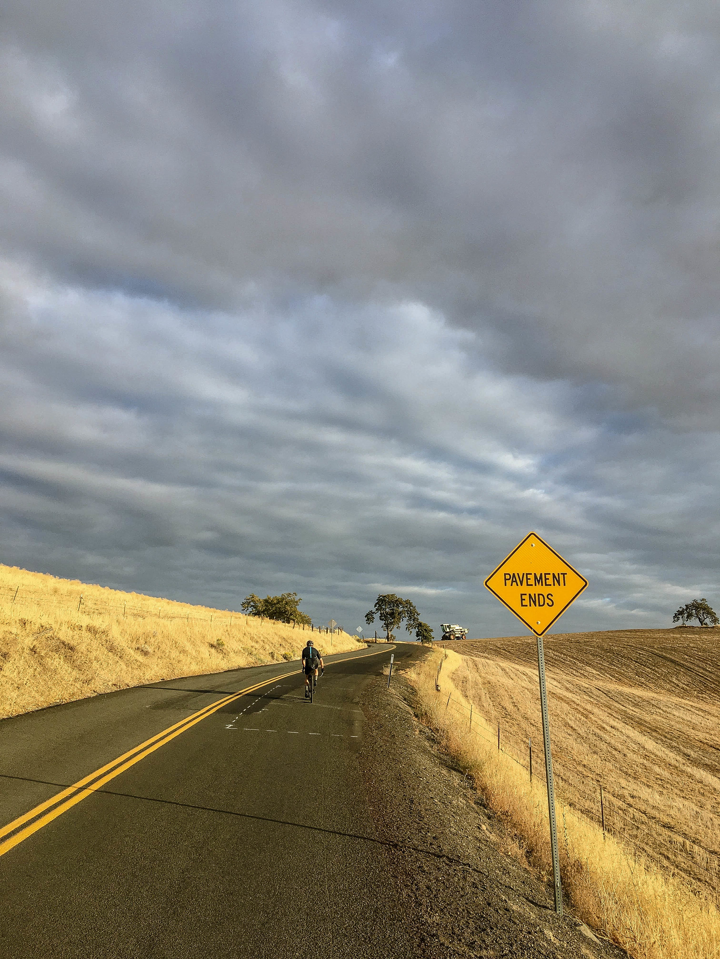
Tollman and I ended up starting a few hours later than originally intended, which turned this into what felt like a lot of night with a break for some light in the middle. We rolled out at around 7PM on Saturday night and it was fully dark by the time we crossed the 205 bridge. Climbing NF 42 into the Gifford at night was an 18 mile ascent which gets rougher and steeper as you get higher. And once up towards the top, very quiet and mysterious. Low temps dipped into the 30s, so a lot of this ride, we were pretty cold. Shoulder season rides are a challenge as you need enough clothes for a 40 degree temperature swing. Bombing down the 10 mile paved NF 54 descent was a highlight, if not a cold one. Filtered water at Paradise creek, then climbed Old Man Pass into the heart of the Gifford.


Another 25 mile mixed terrain climb later, we turned onto NF 8851, and things really picked up. Smooth pristine single lane pavement and a huge descent as light slowly filtered into the sky. The fall colors rolling into Trout Lake at dawn were amazing and vibrant after spending hours only in the small circle of our headlights. That was definitely a highlight, rolling down the 25 mile descent towards what we hoped was a cup of coffee. We didn’t have high expectations that anything would be open there that early, but the old timers were at the counter at Andy’s cafe on an early Sunday morning. A bit of warm liquid definitely raised our spirits, and helped us carry on into morning. Getting through the night was hard, but once day was on us and it warmed up, we both felt pretty good again.

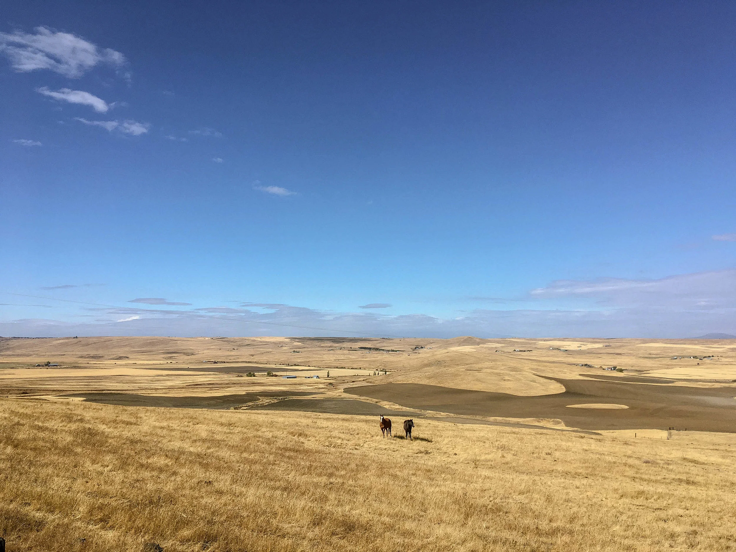
The next section of the route meandered through the dry lands above the Conboy Lake Wildlife refuge. I copied this section of the route from Limberlost’s route “The Gorge Backcountry”. In the fall, again, this was just beautiful. The tan grasses blended so nicely with the colored trees. My favorite part of this section was a closed road called “Private Haul Rd”, which was what seemed to be an old section of the highway that was closed off to motor vehicles. It is an 8 mile gradual descent that eventually connects again with the main road. Despite there being almost no cars out there, a guarantee of no cars is always welcome. We were headed towards the backside of Dalles Mountain, which we’d do the in the reverse to the famous Velodirt 60 of the same name. Tollman had ridden this part a few months earlier when he attempted the Limberlost route solo. He kept referring to the horrible service road that was Dalles Mountain, and it made no sense to me. I had assumed he had gotten off course somewhere. As it turns out, he was absolutely correct. Dalles Mountain road is garbage now. Huge sharp rocks and terrible gravel. I think it must of gotten destroyed during the recent fires and large traction rocks for the trucks must of been dumped. Regardless, I would say that the DM60 is ruined for the time being. Bombing down this rock pile was far from fun, but as I was rolling 52mm Compass tires, it wasn’t that big a deal. Tollman on 40’s had a much slower time of it. Regardless, now, a new goal was in reach - Pizza in The Dalles! 200 miles down, 100 to go.


Stopped in at Freebridge Brewing and enjoyed a pizza each. Stowing 2 pieces for later turned out to be a wise move and we tore ourselves away from civilization and headed out. It was much later in the day than I had hoped to begin the final section. It was already getting towards sunset as we topped Pleasant Hill and dropped into the 5 mile creek drainage. In theory this had seemed like a simple and enjoyable way up to the base of Lookout Mountain. When you’re tired, less cues means less errors - and as much of this climb is on the Japanese Hollow route, I was already familiar with it. Familiarity breeds security, and this also is helpful at the end of a long day. As it turns out, the lower section of 5 mile is rather unpleasant. I’m not a fan of riding in the Dalles in the summer, and this road is the epitome of what I don’t like. Washboard, loose gravel, dust. Luckily, no farm trucks to throw it in our faces. When you’re at home and you look at a 20 mile climb, you think, sure, why not. After 200 miles and no sleep, this sort of climb is rather different.

Darkness descended yet again, and we were climbing. Then we climbed some more, and after we climbed for a long time, we climbed some more. We climbed for 3 hours and 36 minutes to get up this section - not that I was counting. I just made a segment to see if any other idiots have done this. Turns out, no: The Endless Slog.
Don’t.
Upper Five mile connects to Bonny Meadows road into the heart of the 44 trails network. Back in the small circle of my sputtering generator light, our world was small. The climb endless. The gravel, shitty. Hard not to have dark thoughts. Debating what to do at this point. 9PM and we’re nearing the turnoff to lookout mountain. I had ridden much of this segment in June during The Solstice Ride and had planned our departure time and route around doing it in daylight. As nightfall was hours previously, I was extremely wary of getting up to 6000’ and into the rock chunk. Flat tires or mechanicals at near freezing temps would spell very unwanted complex situations to deal with when the mind is weak. I made the call at that point that we bail out. Ok, no problem, let’s just bail out we agree.


Here we are, bailing out. Turns out bailing out just meant to keep climbing on the same shitty gravel, except now we had no route to follow. Not such a big deal as Bonny Meadows is a straightforward washboard slog up to the shoulder of Lookout, and a subsequent high speed paved descent down to highway 35. During the Solstice, our group had been accidentally split into two at this point, and passing the Cooks Meadow trail crossing made me smile inwardly. I could finally see what the other guys ended up doing by dropping down NF 44. It was fast and I could use the power generated from my light to recharge my garmin. While generator lights are pretty much a requirement for this sort of ride, when you are going below 5MPH - which is rather common in shitty gravel, you don’t get a lot of light. My light reaches full brightness at around 12 MPH, so blasting down meant plenty of excess electricity to spare. Tollman’s setup, two battery lights, was very inadequate in this circumstance. When all the USB power is gone and you’re still 60 miles from home on top of Mount Hood — then what?
Getting down to highway 35 meant more or less an end to the stress of being in the unknown. 16 miles to Government Camp the sign said. Uphill of course. There were almost no cars on the highway. It was quiet and dark, plenty of time to start getting properly sleepy again. Occasionally, you would hear an insane Star Wars level sound design coming at you. Around the bend would scream a giant 18 wheeler going at what appeared to be Mach 2. Terrifying. We were debating dropping down highway 26 directly to save time, but after a few of these trucks went by, we decided reconnecting with the original route, and dropping down Still Creek Road was a much better idea.
Back in familiar territory was great, and the 12 mile gravel descent was another huge highlight of the overall ride. At this point our brains had shifted into psychedelic mode, and the flight down the mountain felt more like being in a video game than reality. In total, the 31 mile descent from Barlow Pass on the shoulder of Mt. Hood down to Alder Creek on highway 26 took a bit over 2 hours. That’s a fair reward for the endless slogging we had endured. We kept to the shoulder of highway 26 from this point to Sandy for simplicity and minimum climbs. We started seeing things in the trees, moving, and roadside shapes took on the appearance of livestock standing at attention to watch us pass.
7-11 in Sandy. 2:30AM. 16 miles to go. Wake up a bit.
The final push, turning onto Stone road, into the quiet of the Springwater trail. The approach of the lurking shadow of Powell Butte meant the approach of home. Tollman still had to ride across Portland, which I didn’t envy. Finally done, parking the bike, no energy even for eating anything. After a shower I fell asleep like a gorilla with a hammer had smacked me on the head.